
Mailbox Peak
| Mailbox Peak | |
|---|---|
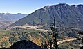
 Northwest aspect, from Mt. Teneriffe | |
| Highest point | |
| Elevation | 4,841 ft (1,476 m)[1][2] |
| Prominence | 121 ft (37 m)[1] |
| Parent peak | Dirtybox Peak [3] |
| Isolation | 0.42 mi (0.68 km)[4] |
| Coordinates | 47°27′45″N 121°38′22″W / 47.462465°N 121.63942°W[1] |
| Geography | |
 Mailbox Peak Location in Washington  Mailbox Peak Mailbox Peak (the United States) | |
| Country | United States |
| State | class 1+ hiking trail |
Mailbox Peak is a 4,841-foot-elevation (1,476 m) mountain located in
U.S. Board on Geographic Names
.
Climate
Mailbox Peak is located in the
snowfall onto the Cascades (Orographic lift). As a result, the west side of the Cascades experiences high precipitation, especially during the winter months in the form of snowfall. Because of maritime influence, snow tends to be wet and heavy, resulting in high avalanche danger.[7] During winter months, weather is usually cloudy, but due to high pressure systems over the Pacific Ocean that intensify during summer months, there is often little or no cloud cover during the summer.[7]
The months May through October offer the most favorable weather for viewing or climbing this peak.
Gallery
-
 Southwest aspect of Mailbox and Dirty Harry's Peak, from Mt. Washington
 -
 Southwest aspect, from Cedar Butte
 -
 North aspect, from Middle Fork Snoqualmie River Road
 -
 The summit mailbox
 -
 Mailbox Peak, seen from Salal Point. Washington State Fire Training Academy at the foot of the mountain. Interstate 90 in lower right. Moolock Mountain in the distance to left. Dirty Harry's Peak on the right side of the ridge.


See also
References
- ^ a b c "Mailbox Peak, Washington". Peakbagger.com.
- ^ ISBN 9781513267289, p. 126
- ^ "Mailbox Peak". Peakbagger.
- ^ "Mailbox Peak - 4,841' WA". listsofjohn.com. Retrieved 2022-04-19.
- ISBN 9781631214998, p. 139
- ISBN 9781640490734
- ^ a b c Beckey, Fred W. Cascade Alpine Guide, Climbing and High Routes. Seattle, WA: Mountaineers Books, 2008.
External links
- Mailbox Peak weather forecast: MountainForecast.com
- Mailbox Peak: Washington Trails Association
Places adjacent to Mailbox Peak | ||||||||||||||||
|---|---|---|---|---|---|---|---|---|---|---|---|---|---|---|---|---|
| ||||||||||||||||