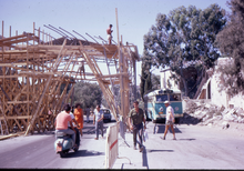
Mandelbaum Gate

The Mandelbaum Gate is a former checkpoint between the
History
Mandelbaum House
The crossing was named after the Mandelbaum House, a three-story building that stood at that location from 1927 to 1948.
During the 1948 Arab–Israeli war, the Mandelbaum House stood between the Jewish neighborhoods and the area under Jordanian control. Mandelbaum's widow, Esther Liba, and her family members abandoned the house on less than a day's notice after being asked to do so by the Haganah. The Haganah then took up residency and repelled Jordanian attacks in the surrounding neighborhoods until a cease-fire was signed. During this period the roof of the house was "protected" by painted plywood cutouts designed to look from above like anti-aircraft guns. As per the status quo agreement, the house remained on the Israeli side. In July 1948, the Jordanians attacked the house with a huge quantity of explosives and the building collapsed with 35 Haganah members inside.[3][5] Part of the front wall with the entry gate remained standing until 1967 as a memorial to the divided Jerusalem. Outside this gate was the official crossing between Israel and Jordan.[3]
A few days after the Six-Day War and the unification of Jerusalem in June 1967, Mayor Teddy Kollek sent in heavy equipment to demolish the remains of the Mandelbaum House. "When a journalist asked him why he committed this act, which was probably beyond his authority to order, he explained that it was a period of chaos in terms of distribution of responsibility, and he did not want to leave this geographic landmark and make the area hefker (abandoned). He was totally unaware of the story behind the house, except for his acquaintance with the Mandelbaum Gate. When asked whether he knew who Mandelbaum had been, he shrugged his shoulders and replied, 'Some German doctor, I think'."[3]
Mandelbaum Gate


The location of the checkpoint was determined by the entrance into the city of the Anglo-Jordanian Arab Legion following the withdrawal of British troops in May 1948. The Jordanians pushed Jewish defenders west and out of the Sheikh Jarrah area.
Clergy, diplomats and
The last person to pass through the Gate was the American journalist Flora Lewis, shortly before the outbreak of the Six-Day War in June 1967. Jordanian forces joined the war on June 5, with a massive bombardment of the Israeli sector of the city.
Israeli forces captured the Jordanian part of Jerusalem within two days and soon tore down the Mandelbaum Gate. Only a historical marker remains.
See also
- "The Mandelbaum Gate" (بوابة مندلباوم), a short story by Emile Habibi (1954)
- The Mandelbaum Gate, a novel by Muriel Spark (1965)
References
- ^ Commander E H Hutchison USNR "Violent Truce: A Military Observer Looks at the Arab-Israeli Conflict 1951-1955" Chapter III The Barrel Incident p 20-30
- ^ Bar-Am, Aviva (25 January 2010). "Former Israel/Jordanian border – No man's land". The Jerusalem Post. Retrieved 21 March 2012.
- ^ a b c d e Regev, Chaya. "The Mandelbaum Gate: Home of the Mandelbaum Family". Yated Ne’eman (Israel-English edition), 5 November 2004, pp. 16–18.
- ^ ISBN 978-1-4165-4440-1.
- ^ "Mandelbaum Gate". Eretz Yisrael Museum. 2010. Retrieved 21 March 2012.
- ^ ISBN 0-7146-5266-0.
