
Marsh Butte
| Marsh Butte | |
|---|---|
 East aspect, from Tonto Trail | |
| Highest point | |
| Elevation | 4,721 ft (1,439 m)[1] |
| Prominence | 301 ft (92 m)[1] |
| Parent peak | Diana Temple (6,683 ft)[1] |
| Isolation | 1.51 mi (2.43 km)[1] |
| Coordinates | 36°07′15″N 112°14′43″W / 36.1207312°N 112.2451402°W[2] |
| Naming | |
| Etymology | Othniel Charles Marsh |
| Geography | |
 Marsh Butte Location in Arizona  Marsh Butte Marsh Butte (the United States) | |
| Location | |
Marsh Butte is a 4,721-foot-elevation (1,439-meter) summit located in the
Topographic relief is significant, as Marsh Butte rises over 2,300 feet (700 meters) above the Colorado River
in half a mile (1 km).
Marsh Butte is composed of
cold semi-arid climate zone.[5]
History

In March 1906, this butte was officially named "Endymion Dome", for
U.S. Board on Geographic Names.[2] George Wharton James described it in his 1910 book "The Grand Canyon of Arizona How to See It" as "a butte of singularly beautiful structure."[7]
The
class 4 east ridge.[8]
See also
Gallery
-
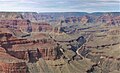 Marsh Butte (centered in bullseye), from Pima Point
 -
 Marsh Butte centered in bullseye, Geikie Peak behind it
 -
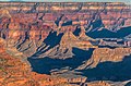
 Aerial view with Marsh Butte lower left, Diana Temple upper left, Geikie Peak centered at bullseye.
 -
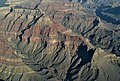 Aerial view of Diana Temple (upper left) and Marsh Butte (lower right)
 -
 Diana Temple centered at top and Marsh Butte centered at bottom.
Aerial view from ENE. -
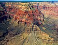
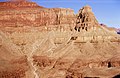 Marsh Butte (end of ridge) formed in Redwall Limestone. Tapeats Sandstone (brown cliff at bottom of photograph), Manakacha Formation (red cliff at top of photograph).


.jpg)


References
- ^ a b c d e "Marsh Butte – 4,721' AZ". Lists of John. Retrieved 2021-01-14.
- ^ a b c d "Marsh Butte". Geographic Names Information System. United States Geological Survey, United States Department of the Interior. Retrieved 2021-01-14.
- ^ N.H. Darton, Story of the Grand Canyon of Arizona, 1917, page 39.
- ISBN 9781934656013.
- ISSN 1027-5606.
- ^ Randy Moore and Kara Felicia Witt, The Grand Canyon: An Encyclopedia of Geography, History, and Culture, 2018, ABC-CLIO Publisher, page 151.
- ^ George Wharton James, The Grand Canyon of Arizona How to See It, 1910, Little Brown and Company, page 40.
- ISBN 9780971088009, page 54.
External links
Wikimedia Commons has media related to Marsh Butte.
- Weather forecast: National Weather Service
- Climbing Marsh Butte: Themtsarecalling.com