Molle Islands National Park
| Molle Islands National Park Queensland | |
|---|---|
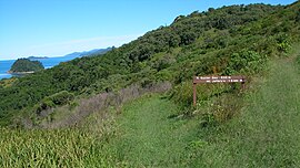
 Track on South Molle Island, 2007 | |
| Nearest town or city | Airlie Beach |
| Coordinates | 20°22′36″S 148°51′27″E / 20.37667°S 148.85750°E |
| Area | 18 km2 (6.9 sq mi) |
| Managing authorities | Queensland Parks and Wildlife Service |
| Website | Molle Islands National Park |
| See also | Protected areas of Queensland |
Molle Islands is a national park in
traditional owners of the islands were the Ngaro people.[1]
Environment

211 different species have been identified in Molle Islands National Park.[2] This includes two vulnerable species, the coastal sheath-tailed bat and the beach stone-curlew.[3]
Recreation

On South Molle Island and Long Island there are marked walking tracks. Most are graded easy and some are suitable for mountain biking. Viewing wildlife, swimming and snorkelling are other popular recreational activities.[1]
Access
The park is accessed by boat from
Shute Harbour.[1] Tour operators provide day tours and ferry transfer is available from nearby resort islands.[1]
Facilities
There are numerous locations available to campers. Some have picnic tables and toilets.[1] Open fires and ash-producing stoves are banned.[1]
See also
References
- ^ a b c d e f "About Molle Islands". Department of National Parks, Recreation, Sport and Racing. 27 August 2013. Retrieved 6 September 2014.
- ^ "Wildlife of Molle Islands National Park". Department of Environment and Heritage Protection. Retrieved 6 September 2014.
- ^ "Rare or threatened wildlife of Molle Islands National Park". Department of Environment and Heritage Protection. Retrieved 6 September 2014.

