
Monongahela Incline
| Monongahela Incline | |
|---|---|
Pittsburgh, Pennsylvania, U.S. | |
| Termini |
|
| Stations | 2 |
| Service | |
| Type | Funicular |
| History | |
| Opened | May 28, 1870 |
| Technical | |
| Line length | 635 feet (194 m) |
| Track gauge | 5 ft (1,524 mm) |
| Electrification | 1935 |
| Operating speed | 6 mph (9.7 km/h) |
Monongahela Incline | |
Pittsburgh, Pennsylvania | |
| Coordinates | 40°25′55″N 80°0′20″W / 40.43194°N 80.00556°W |
| Area | 1 acre (0.40 ha) |
| Built | 1869 |
| Architect | John Endres and Caroline Endres |
| Architectural style | Late 19th and 20th Century Revivals, Second Renaissance Revival |
| NRHP reference No. | 74001742[1] |
| Significant dates | |
| Added to NRHP | June 25, 1974 |
| Designated CPHS | March 15, 1974[2] |
| Designated PHLF | 1970[3] |
The Monongahela Incline is a
It is one of two surviving inclines in Pittsburgh (the other is the nearby
It was listed on the
History

Pittsburgh's expanding industrial base in 1860 created a huge demand for labor, attracting mainly German immigrants to the region. This created a serious housing shortage as industry occupied most of the flat lands adjacent to the South Side of the Monongahela River, leaving only the steep, surrounding hillsides of Mt. Washington, or "Coal Hill", for housing. However, travel between the "hill" and other areas was hindered by the steep terrain and a lack of public transport or good roads.
The predominantly German immigrants who settled on Mt. Washington, remembering the seilbahns (cable cars) of their former country, proposed construction of inclines along the face of Coal Hill.
Prussian-born engineer
Earlier inclines were used to transport coal in the Pittsburgh area, including the
The Monongahela Incline was listed on the
In the 21st century, the Monongahela Incline is operated by Pittsburgh Regional Transit, which operates the rest of Allegheny County's transit system. Transfers can be made between the incline, light rail, and buses free of additional charge.[9] It serves both commuters and visitors, and is a popular tourist attraction.
On February 2, 2019, flooding caused by a broken city water main forced the incline to close.[10] The extensive repairs took time to complete, but the incline reopened 13 weeks later on May 10, 2019.[11]
Statistics
- Length: 635 feet (194 m)
- Elevation: 369.39 feet (112.59 m)
- Grade: 35 degrees, 35 minutes
- Gauge: broad gauge
- Speed: 6 mph (9.7 km/h)
- Passenger Capacity: 23 per car
- Opened: May 28, 1870
- Renovated: 1882 (with steel structure)
- Original steam powerreplaced with electricity: 1935
- Renovated: 1982–83 new track structure, cars and stations
- Renovated: 1994 upper, lower stations, restored cars, replaced electric motors and controls[4]
- Renovated: 2022–23 upper, lower stations, mechanical controls, electrical system, exterior track lighting[12]
Gallery
-
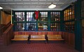 Interior of the lower station
 -
 Ascending
 -
 Descending view
 -
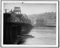 P. & L.E. Ry. Pittsburgh and Lake Erie Railroad station on far riverbank, and two inclines: Monongahela Freight Incline (L) and Monongahela Incline (R), on Mt. Washington, c.1905


See also
 Railways portal
References
- ^ "National Register Information System – (#74001742)". National Register of Historic Places. National Park Service. July 9, 2010.
- ^ "Local Historic Designations". Pittsburgh: Pittsburgh History & Landmarks Foundation. Retrieved August 9, 2011.
- ^ "Historic Landmark Plaques 1968-2009" (PDF). Pittsburgh History and Landmarks Foundation. 2010. Retrieved August 5, 2011.
- ^ ASME. May 11, 1977.
- ^ a b c Leherr, Dave (May 7, 1977). "Inclines Rise to National Landmarks". Pittsburgh Post-Gazette. p. 9.
- ^ "Monongahela and Duquesne Inclines" (PDF). Archived from the original (PDF) on August 16, 2009. Retrieved May 21, 2009.
- ^ "Legendary Ladies" (PDF). Pennsylvania Commission for Women. Archived from the original (PDF) on May 24, 2011. Retrieved March 21, 2006.
- ^ Caroline Enders and John Enders (biographical sketch with photos), in The Pittsburgh Press, December 4, 1955, p. 167. Pittsburgh, Pennsylvania: The Pittsburgh Press (available via Newspapers.com; subscription required).
- ^ "PortAuthority.org - Inclines". www.portauthority.org. Retrieved October 7, 2019.
- ^ "Port Authority making progress to repair flooded Monongahela Incline station". Retrieved April 16, 2019.
- ^ "Monongahela Incline Closed Briefly Friday Morning". May 10, 2019. Retrieved May 21, 2019.
- ^ "StackPath". www.masstransitmag.com. March 6, 2023. Retrieved March 6, 2023.
External links
- Historic American Engineering Record (HAER) No. PA-226, "Monongahela Incline Plane", 28 photos, 36 data pages, 7 photo caption pages
- Lower Station from Google Maps Street View
- Upper Station from Google Maps Street View
- Pittsburgh Transit History Site
| Light rail (list of stations) | .svg) | ||||
|---|---|---|---|---|---|
| Inclines (historical list) | |||||
| Buses and busways (list of routes) | |||||
| Former lines |
| ||||
| Equipment |
| ||||
| Other | |||||
