
Mont-Dore
Mont-Dore | |
|---|---|
 Mont-Dore with the Puy de Sancy in the background | |
.svg) Coat of arms | |
Location of Mont-Dore  | |
 Mont-Dore  Mont-Dore | |
| Coordinates: 45°34′38″N 2°48′35″E / 45.5772°N 2.8097°E | |
| Country | France |
| Region | Auvergne-Rhône-Alpes |
| Department | Puy-de-Dôme |
| Arrondissement | Issoire |
| Canton | Le Sancy |
| Intercommunality | Massif du Sancy |
| Government | |
| • Mayor (2020–2026) | Sébastien Dubourg[1] |
| Area 1 | 35.87 km2 (13.85 sq mi) |
| Population (2021)[2] | 1,237 |
| • Density | 34/km2 (89/sq mi) |
| Time zone | UTC+01:00 (CET) |
| • Summer (DST) | UTC+02:00 (CEST) |
| INSEE/Postal code | 63236 /63240 |
| Elevation | 897–1,883 m (2,943–6,178 ft) (avg. 1,050 m or 3,440 ft) |
| 1 French Land Register data, which excludes lakes, ponds, glaciers > 1 km2 (0.386 sq mi or 247 acres) and river estuaries. | |
Mont-Dore[3] (French pronunciation: [mɔ̃ dɔʁ]; Mont Dòr in Auvergnat, and Mont-Dore-les-Bains), in common usage Le Mont-Dore, is a commune in the Puy-de-Dôme department in Auvergne-Rhône-Alpes in central France.[3]
Geography
Mont-Dore is located in the Massif Central, on the right bank of the Dordogne not far from its source, and 50 km (31 mi) by road southwest of Clermont-Ferrand. The Monts Dore close the valley towards the south.[4]
Climate
| Climate data for Le Mont-Dore, 1220m (1991−2020 normals) | |||||||||||||
|---|---|---|---|---|---|---|---|---|---|---|---|---|---|
| Month | Jan | Feb | Mar | Apr | May | Jun | Jul | Aug | Sep | Oct | Nov | Dec | Year |
| Mean daily maximum °C (°F) | 3.6 (38.5) |
3.6 (38.5) |
6.6 (43.9) |
9.5 (49.1) |
13.7 (56.7) |
17.6 (63.7) |
19.9 (67.8) |
20.0 (68.0) |
16.1 (61.0) |
12.3 (54.1) |
6.9 (44.4) |
4.4 (39.9) |
11.2 (52.1) |
| Daily mean °C (°F) | 0.4 (32.7) |
0.2 (32.4) |
3.0 (37.4) |
5.5 (41.9) |
9.4 (48.9) |
12.9 (55.2) |
14.9 (58.8) |
15.1 (59.2) |
11.6 (52.9) |
8.4 (47.1) |
3.7 (38.7) |
1.4 (34.5) |
7.2 (45.0) |
| Mean daily minimum °C (°F) | −2.7 (27.1) |
−3.2 (26.2) |
−0.6 (30.9) |
1.5 (34.7) |
5.0 (41.0) |
8.3 (46.9) |
10.0 (50.0) |
10.1 (50.2) |
7.1 (44.8) |
4.6 (40.3) |
0.5 (32.9) |
−1.7 (28.9) |
3.2 (37.8) |
| Average precipitation mm (inches) | 197.5 (7.78) |
172.2 (6.78) |
174.9 (6.89) |
178.9 (7.04) |
179.8 (7.08) |
147.8 (5.82) |
141.2 (5.56) |
128.8 (5.07) |
155.8 (6.13) |
183.0 (7.20) |
229.4 (9.03) |
240.1 (9.45) |
2,129.4 (83.83) |
| Source: Météo-France[5] | |||||||||||||
Thermal springs

The
Sodium bicarbonate, iron and arsenic are the principal ingredients of the springs, which are used both for drinking and bathing.[8] Hot baths are characteristic of the treatment; they are believed to be efficacious for tuberculosis, bronchitis, asthma, and nervous and rheumatic paralysis. Due to the elevation and exposure of the valley, the climate of Mont-Dore is relatively severe, and the season only lasts from 15 June to 15 September. The bath-house was rebuilt in 1891–1894.[4]
Ski resort
Mont-Dore is a ski resort with runs on the slopes of the Puy de Sancy and the Puy Ferrand. Thirty runs account for 42 km of downhill skiing, served by a number of lifts of different types. There are also 25 km of cross-country trails.
Sights
In the town park, along the Dordogne, relics of the old
Gallery
-
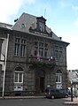 The Hôtel de Ville
 -
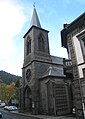 Church
 -
 View from above the Grande Cascade


See also
References
- ^ "Répertoire national des élus: les maires" (in French). data.gouv.fr, Plateforme ouverte des données publiques françaises. 13 September 2022.
- ^ "Populations légales 2021" (in French). The National Institute of Statistics and Economic Studies. 28 December 2023.
- ^ a b Commune de Mont-Dore (63236), code officiel géographique, INSEE
- ^ a b c Chisholm, Hugh, ed. (1911). . Encyclopædia Britannica. Vol. 18 (11th ed.). Cambridge University Press. p. 763.
- ^ "Fiche Climatologique Statistiques 1991-2020 et records" (PDF) (in French). Météo-France. Retrieved September 10, 2023.
- ^ "A Wellness Paradise: Mont-Dore and the Fountain of Youth". Visit Auvergne. Retrieved 14 May 2024.
- ^ "The Thermes du Mont-Dore". Auvergne Sancy. Retrieved 14 May 2024.
- ^ "The isotopic and chemical composition of CO2-rich thermal waters in the Mont-Dore region (Massif-Central, France)". Science Direct. Retrieved 14 May 2024.
| International | |
|---|---|
| National | |
| Geographic | |
| Other | |
This Puy-de-Dôme geographical article is a stub. You can help Wikipedia by expanding it. |