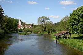
Montbenoît
Montbenoît | |
|---|---|
 The Doubs | |
| Coordinates: 46°59′37″N 6°27′46″E / 46.9936°N 6.4628°E | |
| Country | France |
| Region | Bourgogne-Franche-Comté |
| Department | Doubs |
| Arrondissement | Pontarlier |
| Canton | Ornans |
| Intercommunality | Montbenoît |
| Government | |
| • Mayor (2020–2026) | Lucien Benmehal[1] |
| Area 1 | 5.03 km2 (1.94 sq mi) |
| Population (2021)[2] | 401 |
| • Density | 80/km2 (210/sq mi) |
| Time zone | UTC+01:00 (CET) |
| • Summer (DST) | UTC+02:00 (CEST) |
| INSEE/Postal code | 25390 /25650 |
| Elevation | 762–1,125 m (2,500–3,691 ft) (avg. 790 m or 2,590 ft) |
| 1 French Land Register data, which excludes lakes, ponds, glaciers > 1 km2 (0.386 sq mi or 247 acres) and river estuaries. | |
Montbenoît (French pronunciation: [mɔ̃bənwa]) is a commune in the Doubs department in the Bourgogne-Franche-Comté region in eastern France.

Geography
The commune lies 14 km (8.7 mi) north of
Jura mountains
.
History
In the early 12th century, Landry, Lord of
summit in the area was at the time called Mont Benoît after a hermit named Benoît who lived there. Humbert invited monks to come from Valais and an abbey under St. Columbanus's rule was built by a monk called Nardouin (Norduin) in 1141–1142.[5][6] The town grew up nearby the abbey. Both the abbey and the town were named Montbenoît after the local summit. The abbey later came under the Augustine rule.[6]
In 1947, Montbenoît was proclaimed capital of the Republic of Saugeais by Georges Pourchet, a local hotel owner, who also created the republic on the spot.[citation needed]
Population
| Year | Pop. | ±% |
|---|---|---|
| 1962 | 180 | — |
| 1968 | 205 | +13.9% |
| 1975 | 182 | −11.2% |
| 1982 | 163 | −10.4% |
| 1990 | 238 | +46.0% |
| 1999 | 219 | −8.0% |
| 2008 | 365 | +66.7% |
| 2012 | 396 | +8.5% |
See also
References
- ^ "Répertoire national des élus: les maires" (in French). data.gouv.fr, Plateforme ouverte des données publiques françaises. 13 September 2022.
- ^ "Populations légales 2021". The National Institute of Statistics and Economic Studies. 28 December 2023.
- ^ "Montbenoît" Congrès Archéologique de France 118: p. 306
- OCLC 18349834
- ^ "Montbenoît Abbey" Structurae an architectural database
- ^ a b Base Mérimée: Abbaye d'augustins, Ministère français de la Culture. (in French)
External links
Wikimedia Commons has media related to Montbenoît.


