
Monterey Bay
.png)
Monterey Bay is a bay of the Pacific Ocean located on the coast of the U.S. state of California, south of the San Francisco Bay Area. San Francisco itself is further north along the coast, by about 75 miles (120 km), accessible via CA 1 and US 101.
Santa Cruz is located at the north end of the bay, and Monterey is on the Monterey Peninsula at the south end. The "Monterey Bay Area" is a local colloquialism sometimes used to describe the whole of the Central Coast communities of Santa Cruz and Monterey counties.
Toponymy
.jpg)
The first European to enter Monterey Bay was Juan Rodríguez Cabrillo on November 16, 1542, while sailing northward along the coast on an imperial Spanish naval expedition. He named the bay Bahía de los Pinos,[1] probably because of the forest of pine trees first encountered while rounding the peninsula at the southern end of the bay.[2] Cabrillo's name for the bay was lost, but the westernmost point of the peninsula is still known as Point Pinos.
On December 10, 1595,
The present name for the bay was given in 1602 by


All other place names in the vicinity containing Monterey were so named because of their proximity to the bay. This includes the Presidio of Monterey, City of Monterey, County of Monterey and Monterey Canyon.
Geology
The Monterey Canyon, one of the largest underwater canyons in the world, begins off the coast of Moss Landing, in the center of Monterey Bay. It is 249 miles (401 km) long, although its shape changes regularly because of currents and sediment being left in the area. The canyon is much like that of a continental slope; the biology of the canyon changes significantly in different parts of the canyon.[5]
Flora and fauna
Monterey Bay is home to many species of
Marine protected areas
Soquel Canyon State Marine Conservation Area, Portuguese Ledge State Marine Conservation Area, Pacific Grove Marine Gardens State Marine Conservation Area, Lovers Point State Marine Reserve, Edward F. Ricketts State Marine Conservation Area and Asilomar State Marine Reserve are marine protected areas in Monterey Bay. Like underwater parks, these marine protected areas help conserve ocean wildlife and marine ecosystems.
Communities around Monterey Bay


Clockwise around the bay, generally from north to south. Inland communities are indented:
- Santa Cruz
- Capitola
- Aptos
- Rio del Mar
- La Selva Beach
- Moss Landing
- Marina
- Seaside
- Sand City
- Monterey
- New Monterey
- Pacific Grove
- Carmel
- Carmel Highlands
In popular culture
Apple's desktop operating system, macOS Monterey, is named after this region.
Gallery
-
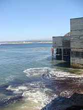 Monterey Bay seen with the old Cannery Foundations
 -
 One of many beaches along the Monterey Bay coast line
 -
 Monterey Bay as seen frompower plantis visible in the distance.
 -
 Scuba diving lessons in the bay, near Monterey, California
 -
 Albert Bierstadt, "Bay of Monterey", oil on paper, undated
 -
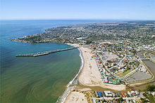 Aerial view of the north end of Monterey Bay at Santa Cruz


See also
References
- ^ ASIN B000FMOPP4.
- ^ ISBN 978-1-880478-00-4.
- ASIN B001K5A42S.
- ^ "Dr. Hart's Mansion - Pacific Grove, California". hartmansion.com. Retrieved January 6, 2021.
- ^ "Monterey Canyon: Stunning deep-sea topography revealed | MBARI". www.mbari.org. February 22, 2016. Retrieved January 10, 2018.
Further reading
- Palumbi, Stephen R; Sotka, Carolyn (November 12, 2010). The Death and Life of Monterey Bay: A Story of Revival. Island Press. ISBN 978-1610911900.
External links
 Monterey Bay travel guide from Wikivoyage
- Live Monterey Bay Web Cam
- Monterey Bay National Marine Sanctuary website
| Bodies of water & submarine features |  | |
|---|---|---|
| Counties | ||
| Major cities | ||
| Cities and towns 50k-100k | ||
| Cities and towns 25k-50k | ||
| Cities, towns, and census-designated places <25k | ||
| Ghost towns | ||
36°48′N 121°54′W / 36.800°N 121.900°W
| International | |
|---|---|
| National | |
| Other | |