Monticello–Bloomfield Border Crossing
| Monticello–Bloomfield Border Crossing | |
|---|---|
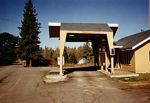
 The US Border Inspection Station at Monticello, Maine as seen in 1996. | |
| Location | |
| Country | United States; Canada |
| Location |
|
| Coordinates | 46°19′03″N 67°46′58″W / 46.317568°N 67.78264°W |
| Details | |
| Opened | 1939 |
| US Phone | (207) 488-6958 |
| Canadian Phone | (506) 328-3872 |
| Hours | 8:00 AM-4:00 PM Eastern, Closed Sundays November - May |
| Website www | |
The Monticello–Bloomfield Border Crossing connects the towns of Monticello, Maine and Bloomfield, New Brunswick on the Canada–US border.
This crossing is not heavily trafficked,[1] and is among the few that is not open on Sundays. The inspection canopy shown in this photo was dismantled shortly after the photo was taken in 1996. The border station has since been painted grey. A Remote Video Inspection System operated at this location between 1997 and 2001 to enable people to enter the US when the border station was not open. In 2002, a gate was installed to prevent people from crossing when the border stations are closed.
History
The US originally built a red brick border station at this crossing in 1937. In 1974, local residents organized to oppose its replacement, citing that the original border station was an "architecturally attractive landmark." The
Canada last upgraded its border station at Bloomfield in 1991.
See also
References
- ^ "Chapter 1: Eastern Maine". United Divide: A Linear Portrait of the USA/Canada Border. The Center for Land Use Interpretation. Winter 2015.
