
Mount Prater
| Mount Prater | |
|---|---|
 Southwest aspect | |
| Highest point | |
| Elevation | 13,471 ft (4,106 m)[1][2] |
| Prominence | 85 ft (26 m)[2] |
| Parent peak | Mount Bolton Brown (13,491 ft)[3] |
| Isolation | 0.74 mi (1.19 km)[3] |
| Listing | Sierra Peaks Section Vagmarken Club Sierra Crest List[4] |
| Coordinates | 37°02′12″N 118°26′05″W / 37.0367929°N 118.4347054°W[5] |
| Naming | |
| Etymology | Alfred William Prater |
| Geography | |
 Mount Prater Location in California  Mount Prater Mount Prater (the United States) | |
| Location | class 2 Southeast ridge[1] |
Mount Prater is a 13,471-foot-elevation (4,106 meter) mountain summit located on the shared border of Fresno County and Inyo County in California, United States.
Description
The peak is set on the crest of the
Topographic relief
is significant as the summit rises 2,100 feet (640 meters) above Tinemaha Lake in one mile.
Climbing
The
peakbagging
list generates climbing interest in this peak.
Etymology
This landform's name commemorates Alfred William Prater (1902–1929), mathematics professor at University of California and the mountaineer who was first to climb this peak with his wife in the summer of 1928.[5] The toponym was officially adopted in 1930 by the United States Board on Geographic Names.[5]
Climate
Mount Prater is located in an
snowfall
onto the range.
See also
Gallery
-
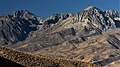 Mt. Prater centered between Split Mountain (left) and Birch Mountain (right). From northeast.
 -
 Tinemaha Lake seen from Mount Prater
 -
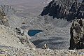
 Lake 11597 seen from Mount Prater


References
- ^ ISBN 9781594857386, p. 224
- ^ a b "Mount Prater, California". Peakbagger.com. Retrieved 2022-06-04.
- ^ a b "Prater, Mount - 13,471' CA". listsofjohn.com. Retrieved 2022-06-04.
- ^ "Vagmarken Sierra Crest List". Angeles Chapter, Sierra Club. Retrieved 2022-06-04.
- ^ a b c d "Mount Prater". Geographic Names Information System. United States Geological Survey, United States Department of the Interior. Retrieved 2022-06-04.
- ^ Wayne N. Sawka (1982), North America, United States, California, Sierra Nevada, Mount Prater, Hidden Couloir, American Alpine Journal
- ^ "Climate of the Sierra Nevada". Encyclopædia Britannica.
External links
- Weather forecast: Mount Prater
Places adjacent to Mount Prater | ||||||||||||||||
|---|---|---|---|---|---|---|---|---|---|---|---|---|---|---|---|---|
| ||||||||||||||||