
Mount Tommy Thompson
| Mount Tommy Thompson | |
|---|---|
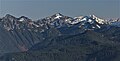
 Northeast aspect, from Hidden Lake Peaks | |
| Highest point | |
| Elevation | 6,780 ft (2,067 m)[1] |
| Prominence | 1,620 ft (490 m)[1] |
| Parent peak | Peak 7425[2] |
| Isolation | 3.16 mi (5.09 km)[2] |
| Coordinates | 48°26′45″N 121°19′03″W / 48.445965°N 121.317519°W[1] |
| Geography | |
 Mount Tommy Thompson Location in Washington  Mount Tommy Thompson Mount Tommy Thompson (the United States) | |
| Country | United States |
| State | Washington |
| County | Skagit |
| Protected area | Glacier Peak Wilderness |
| Parent range | North Cascades |
| Topo map | USGS Snowking Mountain |
Mount Tommy Thompson is a 6,780-foot-elevation (2,070-meter) mountain summit located in
Etymology
The mountain is unofficially named in honor of forest ranger Tommy Thompson (1884–1969). Born in England, his family immigrated to the United States in 1885. Tommy worked for the Forest Service from 1904 to 1943 in the Skagit district of the North Cascades. He made the first ascent of Ruby Mountain in 1916.[3]
Climate
Mount Tommy Thompson is located in the
Geology
The North Cascades features some of the most rugged topography in the
The history of the formation of the Cascade Mountains dates back millions of years ago to the late
During the Pleistocene period dating back over two million years ago, glaciation advancing and retreating repeatedly scoured the landscape leaving deposits of rock debris.[4] The U-shaped cross section of the river valleys is a result of recent glaciation. Uplift and faulting in combination with glaciation have been the dominant processes which have created the tall peaks and deep valleys of the North Cascades area.
Gallery
-
 Northwest aspect of Mount Tommy Thompson (centered) seen from Sauk Mountain
 -
 Mt. Tommy Thompson seen from Hidden Lake Peak Lookout


References
- ^ a b c d "Mount Tommy Thompson, Washington". Peakbagger.com.
- ^ a b "Mount Tommy Thompson - 6,780' WA". listsofjohn.com. Retrieved 2021-08-14.
- ^ a b c Beckey, Fred W. Cascade Alpine Guide, Climbing and High Routes. Seattle, WA: Mountaineers Books, 2008.
- ^ a b c d Kruckeberg, Arthur (1991). The Natural History of Puget Sound Country. University of Washington Press.
External links
- Tommy Thompson biography: Skagitriverjournal.com
- Glacier Peak Wilderness (Mt. Baker-Snoqualmie National Forest) U.S. Forest Service
- Mount Tommy Thompson aerial photo: PBase