
Mount Wordie
| Mount Wordie | |
|---|---|
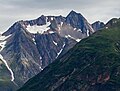
 Mount Wordie, west aspect (summit at upper left) | |
| Highest point | |
| Elevation | 4,700 ft (1,400 m)[1] |
| Prominence | 1,046 ft (319 m)[1] |
| Parent peak | Mount Merriam (5,083 ft)[1] |
| Isolation | 1.28 mi (2.06 km)[1] |
| Coordinates | 58°56′27″N 136°28′30″W / 58.94083°N 136.47500°W[1] |
| Geography | |
 Mount Wordie Location of Mount Wordie in Alaska | |
| Location | |
| Parent range | Takhinsha Mountains[1] Alsek Ranges Saint Elias Mountains |
| Topo map | USGS Mount Fairweather D-2 |
| Climbing | |
| Easiest route | South slope, West ridge[2] |
Mount Wordie is a 4,700+ foot (1,433+ meter) mountain summit located in
Glacier Bay
, which is a popular destination for cruise ships.
Etymology
The mountain was named by members of a 1941 Glacier Bay expedition for
polar explorer, glacier geologist, and President of the Royal Geological Society from 1951 through 1954.[3] Wordie visited nearby Muir Glacier in Glacier Bay in 1913.[3]
Climate
Based on the Köppen climate classification, Mount Wordie has a subarctic climate with cold, snowy winters, and mild summers.[4] Winter temperatures can drop below −20 °C with wind chill factors below −30 °C. The months May through June offer the most favorable weather for viewing or climbing the peak.
See also
Gallery
-
 Mt. Wordie from southwest
 -
 James Wordie


References
- ^ a b c d e f g "Mount Wordie, Alaska". Peakbagger.com. Retrieved 2020-02-05.
- ^ "Mount Wordie". Bivouac.com. Retrieved 2020-02-05.
- ^ a b c "Mount Wordie". Geographic Names Information System. United States Geological Survey, United States Department of the Interior. Retrieved 2020-02-05.
- ISSN 1027-5606.
External links
- Weather forecast: Mount Wordie