
Nahant Beach Reservation
| Nahant Beach Reservation | |
|---|---|
Massachusetts Department of Conservation and Recreation | |
| Website | Lynn Shore & Nahant Beach Reservation |
Nahant Beach Reservation is a protected coastal reservation covering 67 acres (27 ha) of beach and recreational areas in the
traffic circle at the reservation's northern end.[3][4] The reservation is part of the Metropolitan Park System of Greater Boston
.
History
In the early 1900s, privately owned shoreline property at Nahant Beach and Lynn Shore was acquired by the Metropolitan District Commission to create two abutting reservations. Following the purchases, buildings including the Hotel Nahant were removed to give the public access to beaches and to protect natural features.[3] A bathhouse was built at the north end of the reservation in 1901; beach shelters, benches, and a bridle path were added in the early 20th century.[5]
Gallery
-
 windsurfer
 -
 surfer
 -
 shorebirds, with Little Nahant in the distance
 -

-
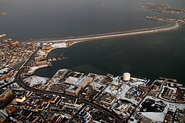 aerial view


References
- ^ a b "Long Beach". Geographic Names Information System. United States Geological Survey, United States Department of the Interior.
- ^ "2012 Acreage Listing" (PDF). Department of Conservation and Recreation. April 2012. Retrieved January 19, 2014.
- ^ a b "Lynn Shore & Nahant Beach Reservation". Department of Conservation and Recreation. Retrieved June 7, 2021.
- ^ "Lynn Shore & Nahant Beach Reservation Map". Department of Conservation and Recreation. Retrieved June 7, 2021.
- ^ Massachusetts Historical Commission (June 2003). "Nahant Beach Boulevard". National Register of Historic Places Inventory Nomination Form. National Park Service. Retrieved March 20, 2017.
External links
Wikimedia Commons has media related to Nahant Beach.
- Lynn Shore & Nahant Beach Reservation Department of Conservation and Recreation
- Lynn Shore & Nahant Beach Reservation Map Department of Conservation and Recreation
- Nahant Beach (commercial website)