
National Route 40 (Argentina)
You can help expand this article with text translated from the corresponding article in Spanish. Click [show] for important translation instructions.
|
.svg)

National Route 40, also known as RN40 or "Ruta 40", is a
RN40 is the longest route in South America and one of the longest in the world alongside such routes as
The road crosses the provinces of
.Description
This section needs additional citations for verification. (May 2017) |
Incorporation of sections of other highways into RN40, along with paving, is part of an Argentine government initiative to promote national tourism by drawing upon the legendary and some say mythical attraction attached to the route. The attraction is international in scope, and many websites around the world advertise the private and commercial adventures associated with travel on this roadway.
There are a number of internationally important sites along this route. Cueva de las Manos contains cave art dating back some 13,000 years. Los Glaciares National Park, the second largest national park in Argentina, and the Calchaquí Valleys also are near the route.
North
This section needs additional citations for verification. (May 2017) |
RN40 begins at the Bolivian border at La Quiaca. From there it goes west to San Juan de Oro, then turns south, parallel to the Andes, by San Antonio de los Cobres and Cachi and through the Calchaquí Valleys to Cafayate, then via Belén, Villa Unión to San Juan. From San Juan, RN40 is a busy highway to Mendoza. [3]
South
This section needs additional citations for verification. (May 2017) |


From Mendoza, RN40 continues south to Pareditas,
The road then enters the most remote part of its route. 124 kilometres (77 mi) south of Perito Moreno is the junction with a side road to Cueva de las Manos, and 3 kilometres (1.9 mi) farther is the tiny settlement of
History
Since the beginning of its construction in 1935,[citation needed] the route has changed several times. On 24 November 2004, the Argentine national directorate of highways (Dirección Nacional de Vialidad) promulgated Resolution 1.748/04,[citation needed] which changed the milestone markings and placed the "zero" kilometer stone at the new southernmost extreme of the road, at Cabo Virgenes, near the Straits of Magellan.[1] Because in January 2009 there was no roadway constructed between the new marker location at Cabo Virgenes and Punta Loyola (near Río Gallegos), the provisional driving starting point as of early 2009 was at the KM 100 location.[citation needed]
Before 2004, RN40 was divided into "Ruta 40 Sur" (south) and "Ruta 40 Norte" (north) with the earlier "traditional" zero-km starting point at the intersection of San Martín and Garibaldi streets in the city of Mendoza, in Mendoza Province.[citation needed] That zero-km marker was subsequently moved to the eastern access point of that city, at the intersection of RN7 and Gob Avenue. Ricardo Videla (also known as Avenida Costanera).[citation needed] The intent of new legislation and remarking of roadways will move the traditional northern terminus of RN40 to the frontier with Bolivia near the location of Ciénaga de Paicone.[citation needed]

Latest developments
This paragraph needs additional citations for verification. (May 2017) |
On 20 May 2006, the Argentine national highway directorate and the Jujuy provincial highway department signed an agreement in which sections of Jujuy provincial highways 85, 70, 74, 7, 64, 65, and 5 were transferred to national control for the construction of the so-called "Mining Corridor", which will become the new path of RN40, more toward the west in that province. The agreement was ratified by provincial law 5520. Accordingly, the section of the road between San Antonio de los Cobres and Abra Pampa is renamed National Route 1V40.
In February 2009, President
Gallery
-
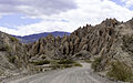 Interesting geology on Ruta 40, N Argentina
 -
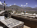 Graves along Ruta 40
 -
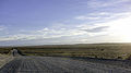 Expansive landscape on Ruta 40 in Northern Argentina
 -
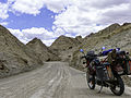 Ruta 40 and a Kawasaki KLR 650
 -
 Gauchito Gil altar
 -
 Ruta 40 near Bariloche (Argentina)
 -
 Ruta 40 near Bajo Caracoles


.jpg)
.jpg)
References
- ^ a b c Arias, Mariela (26 April 2009). "Terminar la ruta 40 ahora cuesta el doble". La Nación (in Spanish). Retrieved 20 October 2014.
- ^ "La nueva ruta 40 promueve el desarrollo de la zona cordillerana Diario la Capital de Mar del Plata".
- ^ Google (27 July 2021). "Overview map of RN-40" (Map). Google Maps. Google. Retrieved 27 July 2021.
- ^ South American Handbook 2009,p.247
| National |
| ||||||||||||
|---|---|---|---|---|---|---|---|---|---|---|---|---|---|
| Provincial |
| ||||||||||||