
New Luce
| New Luce | |
|---|---|
 | |
 New Luce Location within Dumfries and Galloway | |
| OS grid reference | NX174647 |
| Council area | |
| Lieutenancy area | |
| Country | Scotland |
| Sovereign state | United Kingdom |
| Post town | NEWTON STEWART |
| Postcode district | DG8 |
| Dialling code | 01581 |
| Police | Scotland |
| Fire | Scottish |
| Ambulance | Scottish |
| UK Parliament | |
| Scottish Parliament | |
New Luce (
New Luce is also the principal village within the parish. The coast to coast walk, the
Places of interest
A viaduct carried the Stranraer-Glasgow railway over the Main Water of Luce. Down the river from the viaduct is a pool called Bloody Wheel where the Hays of
Archaeology
The Caves of Kilhern, between 2,000 and 3,000 years old, are in south New Luce.
Cairn na Gath ("cairn of the wild cat"), near Balmurrie, is a chambered long cairn dating to the neolithic (later stone-age). At the south end there are remains of huts or enclosures.
Cairn Macneilie, 100 metres (330 ft) north-west of Cruise, New Luce, is a Bronze Age round cairn, 56 feet (17 m) in diameter and 3 feet 6 inches (1.07 m) high.
Forts
Rev. George Wilson, in his Archaeological and Historical Collections relating to Ayrshire and Galloway, lists forts in New Luce:[10]
- Cruise Back Fell, fort marked on the map as two cairns, 80 ft long, on the Fell of Cruise or High Galdenoch.[11]
- Gleniron Several fort with a cluster of green rings, and a large ditch and mote.[12][13]
- Mid Gleniron[14]
- Mid Gleniron tomb, where the long cairn had enclosed an earlier smaller one.[15]
- Garvilland Iron-age hill fort on the Bennan, double at the one end and with hut circles.[16]
- Klashherne, two rings, and three more, not on O.S. map.[17]
- Balmurrie, ring with two hut circles.
Gallery
-
 'Caves' of Kilhern: six neolithic chambered cairns, estimated at between 2000 and 3000 years old
 -
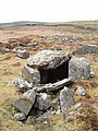
 Cairn na Gath, near Balmurrie
 -
 Cairn na Gath. This is a chambered long cairn dating to the neolithic
 -
 Bennan of Garvilland Iron Age hill fort
 -
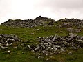 Bennan of Garvilland hill fort - entrance
 -
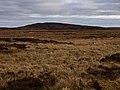 Bught Fell and Kilhern Moss
 -
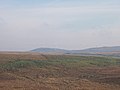
 Looking across open moorland to the cairn on Cairn Park, behind Glenchamber
 -
 Southern Upland Way near Cairn Macneilie, Cruise
 -
 A windfarm at Artfield Fell, east of New Luce
 -
 Laggangairn Standing Stones
 -
 Viaduct over Main Water of Luce


See also
References
- ^ "Community Councils". Archived from the original on 2 May 2009.
- ^ "View: A map of the county of Wigton. - Counties of Scotland, 1580-1928 - National Library of Scotland". Maps.nls.uk. Retrieved 9 September 2012.
- ^ "Hello Folks, - New Luce | A History".
- ^ National Archives of Scotland GD72/142(i). 13 May 1662. Bond by Sir Thomas HAY, younger of (Castle of) Park, and William LIN of Large, as cautioners to William GORDON of Craiglaw
- ^ National Archives of Scotland. GD135/798, 800, 804, 955. c.1687
- ^ "explorebritain.info -".
- ^ "Lagafater Lodge". Canmore. Historic Environment Scotland. Retrieved 9 September 2016.
- ^ "Cairn McNeilie". Megalithic Portal.
- ^ "Cruise, Cairn Macneilie | Canmore".
- ^ Archaeological and Historical Collections relating to Ayrshire and Galloway. vol.V. pp.63-64 https://archive.org/stream/cu31924092901606#page/n115/mode/2up
- ^ "Cruise Back Fell | ScotlandsPlaces".
- ^ "Mid Gleniron | ScotlandsPlaces".
- ^ "Mid Gleniron I and II (Chambered Tomb) | The Modern Antiquarian | Mid Gleniron I and II (Chambered Tomb)". Archived from the original on 23 January 2005.
- ^ "Mid Gleniron | ScotlandsPlaces".
- ^ Discovery and Excavation 1963, 51ff ; Corcoran. 1964 http://www.dgnhas.org.uk/
- ^ "Mid Gleniron | ScotlandsPlaces".
- ^ "Bught Fell | Canmore".
| International | |
|---|---|
| National | |