
Old Luce
| Old Luce | |
|---|---|
 Old Luce Location within Dumfries and Galloway | |
| Council area | |
| Lieutenancy area | |
| Country | Scotland |
| Sovereign state | United Kingdom |
| Police | Scotland |
| Fire | Scottish |
| Ambulance | Scottish |
| UK Parliament | |
| Scottish Parliament | |
Old Luce is a civil parish in Dumfries and Galloway, Scotland. It lies in the Machars peninsula, in the traditional county of Wigtownshire. The parish is around 10 miles (16 km) long and 8 miles (13 km) broad, and contains 40,350 acres (16,330 ha).[1]
It was anciently named Glenluce which was divided in 1646 into two parts, the northern one named New Luce, and the southern one named Old Luce.[2]
Villages and places in Old Luce
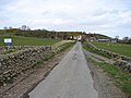
The town of Glenluce and Glenluce Church are in Old Luce Parish, as is Glenluce Abbey. In 1846 in the Topographical Dictionary of Scotland, Samuel Lewis wrote that the village of Glenluce was situated upon the road leading from Newton Stewart to Stranraer. "The church, erected in 1814, is a commodious edifice, and situated close to the village. The members of the United Secession have a place of worship. There are several other schools, of which two are connected with dissenters, and one is supported by the Hay family."[6]
Archaeology
From Glenluce Sands there have been recovered "more objects of antiquity than from any area of similar extent in Scotland". The relics range from neolithic to mediaeval times.[7]
St. John's Chapel at The Knock of Luce was at one time a chapel of St. John. The tenant, Mr. Wilson, told Rev. George Wilson of Glenluce that he removed three distinct paved floors, one above the other. This indicated a long occupation.[8]
Forts and brochs
Rev. George Wilson of Glenluce, in his Archaeological and Historical Collections relating to Ayrshire and Galloway, relates that Wigtownshire contains about sixty forts; 15 in Mochrum, 4 in Glasserton, 10 in Whithorn, and several more in the other parishes not named in his list. He lists the following forts in Old Luce:[9][10]
- Three at Glenhinnie or Glenhinney hut circles, Dunragit Moor [11]
- Two at Glenwhan, Dunragit
- Two in a wood called Baraigle near Dunragit
- Roon Dounan, Dunragit House, north Dunragit Village [12] A stone-built 5th-6th century fort of Rheged on a natural hillock of outcropping rock, 12–14 ft high with an 18 ft terrace on the west side.
- Two on Craig, each with a hut circle. (Perhaps Old Hall of Craig at Airyhemming)
- Three forts at Airyhemming, one with a cup-shaped floor at one end.[13]
- Stairhaven broch.[14]
- A fort 1/4 mile south of the pier shown on the O.S. map as a cairn.[15]
- Near Low Sunonness fort called Garliachen.[16]
- Ring on Mull of Sunonness. (perhaps Garliachen)
- On Barhaskine at the Carlinwark.[17]
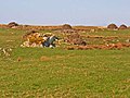
- Fortified town on Knock Hill. The Knock, Old Luce, or Knock of Luce or Knock Fell fort [18] This ancient fortified village stands on the highest hill in Old Luce and may have been built by the makers of the extensive lake dwellings in Machermore Loch about 2 miles to the west. There was an outer defence at the west end on a lower shelving slope. It had an entrance gap of about 10 feet at each end, that at the south-western end appeared to have heavy defences, but the whole fort was dilapidated to build a dry stone wall along the south-side of the Fell. There were traces of 6 or 7 hut circles along the line of fortification and outside on a small flat space on the steep northern side (click on photo below) there was a half-circle of about 20 ft in diameter. Down the western-slope there was a cluster of small cairns, and a cluster of green hut circles.[19]
- Ring on Barnsallzie moor. Barnsallie Hut Circle [20]
- Circular fort at Drumearnachan (at Barlea or Barfad, Kirkcowan), not on O.S. map, but detailed on p. 56, vol.III.[10]
- Mouth of River Piltanton Corrylinn or Corachlinn.
- High Torrs called Knockdoon.
Droughdool Mote or Mound, south Dunragit Village, has a base of 156 ft diameter, is 30 ft high with a level top of 40 ft diameter.[21]
Dunragit
Crannogs
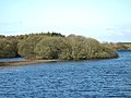
Whitefield Loch has two crannogs: Dormans Island crannog of 250BC; and Tree Island crannog. The latter is now on dry land due to the fallen water level in the Loch.[24] Whitefield is near Machermore, ancient castle of the MacDowall Clan.
Gallery
-
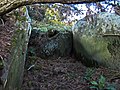
 Carscreugh Castle
 -
 Milton Bridge near site of Kirkchrist chapel and well
 -
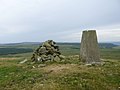 Knock Fell trig (Knock Hill Fort)
 -
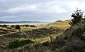
 Knock of Luce (Knock Fell), view of Fort location from Mull of Sinniness
 -
 Knock of Luce ancient village fort. Rock face on steep northern slope
 -
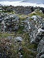 Stairhaven Iron-age broch - intramural stairs
 -
 Black Cairn
 -
 High Gillespie chambered cairn
 -
 Garliachen Fort, Laigh Sinniness, Old Luce
 -
 near 3 forts at Airyhemming (Arehemen)
 -
 possibly Tree Island Crannog, Whitefield Loch - Machermore Loch
 -
 Dorman's Island Crannog, Whitefield Loch - Machermore Loch
 -
 Machermore, Barony Glenluce, ofClan Macdowall
 -
 Glenwhan Garden in Dunragit
 -
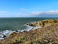
 Ringadoo Point near Dunragit


See also
References
- ^ "Parish of Old Luce from the Gazetteer for Scotland". Scottish-places.info.
- ^ Chalmers, George (7 July 1810). "Caledonia; or, An account, historical and topographic, of North Britain; from the most ancient to the present times". London, Cadell. Retrieved 7 July 2022 – via Internet Archive.
- ^ Chambers, William; Chambers, Robert (7 July 1838). "The gazetteer of Scotland. [With plates and maps.]". Glasgow. Retrieved 7 July 2022 – via Internet Archive.
- ^ "Parish lists of Wigtownshire and Minnigaff, 1684". 1916.
- ^ "Glenluce-Online Old Luce Community Council". Archived from the original on 26 July 2013. Retrieved 17 October 2012.
- ^ A Topographical Dictionary of Scotland, by Samuel Lewis. 1846
- ^ "Old Luce Cursus Cursus : The Megalithic Portal and Megalith Map". Archived from the original on 14 November 2012.
- ^ "Ancient Church dedications in Scotland". Archive.org.
- ^ "Archæological and historical collections relating to Ayrshire & Galloway". Edinburgh, Printed for the Ayrshire and Galloway archæological association. 7 July 1878. Retrieved 7 July 2022 – via Internet Archive.
- ^ a b "Archæological and historical collections relating to Ayrshire & Galloway". Edinburgh, Printed for the Ayrshire and Galloway archæological association. 7 July 1878. Retrieved 7 July 2022 – via Internet Archive.
- ^ "Dunragit Moor | Canmore". Canmore.rcahms.gov.uk.
- ^ "Round Dounan | Canmore". Canmore.org.uk. Retrieved 7 July 2022.
- ^ "Old Hall of Craig, Airyhemming". Canmore.rcahms.gov.uk.
- ^ "Stairhaven Broch - Broch or Nuraghe in Scotland in Dumfries and Galloway". Megalithic.co.uk. Retrieved 7 July 2022.
- ^ "View map: Wigtownshire, sheet 23 (Includes: Old Luce) - Ordnance Survey Six-inch 1st edition, Scotland, 1843-1882". Maps.nls.uk.
- ^ "Garliachen, Laigh Sinniness". Canmore.rcahms.gov.uk.
- ^ "Craignarget Hill, The Carlinwark | Canmore". Canmore.org.uk. Retrieved 7 July 2022.
- ^ "The Megalithic Portal and Megalith Map: Knock Hill Fort". Archived from the original on 25 November 2004.
- ^ Antiquities of Glenluce. Rev. George Wilson. 1899
- ^ "Barnsallie Fell | Canmore". Canmore.org.uk. Retrieved 7 July 2022.
- ^ "Droughdool Mote | Canmore". Canmore.org.uk. Retrieved 7 July 2022.
- ^ Dunragit Cursus Excavations "Dumfries and Galloway Excavations: Home Page". Archived from the original on 19 May 2014. Retrieved 3 September 2013. Dunragit Cursus Excavations
- ^ "Dumfries and Galloway Excavations: Home Page". Archived from the original on 19 May 2014. Retrieved 3 September 2013.
- ^ "Dorman's Island, Whitefield Loch". Canmore.rcahms.gov.uk.
| International | |
|---|---|
| National | |