
New Milford, Pennsylvania
New Milford, Pennsylvania | |
|---|---|
570 | |
| FIPS code | 42-53880 |
New Milford is a borough in
Geography
New Milford is located at 41°52′35″N 75°43′35″W / 41.876447°N 75.726445°W.[4]
According to the United States Census Bureau, the borough has a total area of 1.0 square mile (2.6 km2), all land.
History
The borough of New Milford was formed from part of New Milford Township in December 1859.[5]
Demographics
| Census | Pop. | Note | %± |
|---|---|---|---|
| 1860 | 414 | — | |
| 1870 | 600 | 44.9% | |
| 1880 | 803 | 33.8% | |
| 1890 | 763 | −5.0% | |
| 1900 | 715 | −6.3% | |
| 1910 | 654 | −8.5% | |
| 1920 | 644 | −1.5% | |
| 1930 | 782 | 21.4% | |
| 1940 | 807 | 3.2% | |
| 1950 | 880 | 9.0% | |
| 1960 | 1,129 | 28.3% | |
| 1970 | 1,143 | 1.2% | |
| 1980 | 1,040 | −9.0% | |
| 1990 | 953 | −8.4% | |
| 2000 | 878 | −7.9% | |
| 2010 | 868 | −1.1% | |
| 2020 | 817 | −5.9% | |
| 2021 (est.) | 814 | [3] | −0.4% |
| Sources:[6][7][8][2] | |||
At the
Of the 379 households, 29.3% had children under the age of 18 living with them, 43.5% were married couples living together, 11.1% had a female householder with no husband present, and 38.8% were non-families. 31.7% of households were one person, and 10.3% were one person aged 65 or older. The average household size was 2.29 and the average family size was 2.85.
In the borough the population was spread out, with 22.4% under the age of 18, 62.2% from 18 to 64, and 15.4% 65 or older. The median age was 40.6 years.
The median household income was $38,611 and the median family income was $50,000. Males had a median income of $40,870 versus $26,071 for females. The per capita income for the borough was $20,067. About 8.3% of families and 11.7% of the population were below the
-
 Pratt Memorial Library
 -
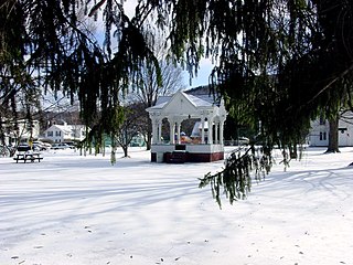 Bandstand in March


See also
References
- ^ "ArcGIS REST Services Directory". United States Census Bureau. Retrieved October 12, 2022.
- ^ a b "Census Population API". United States Census Bureau. Retrieved October 12, 2022.
- ^ a b Bureau, US Census. "City and Town Population Totals: 2020—2021". Census.gov. US Census Bureau. Retrieved August 5, 2022.
- ^ "US Gazetteer files: 2010, 2000, and 1990". United States Census Bureau. February 12, 2011. Retrieved April 23, 2011.
- ^ "County info". The Susquehanna County Historical Society & Free Library Association. Retrieved February 8, 2016.
- ^ "Census of Population and Housing". U.S. Census Bureau. Retrieved December 11, 2013.
- ^ "U.S. Census website". United States Census Bureau. Retrieved January 31, 2008.
- ^ "Incorporated Places and Minor Civil Divisions Datasets: Subcounty Resident Population Estimates: April 1, 2010 to July 1, 2012". Population Estimates. U.S. Census Bureau. Archived from the original on June 11, 2013. Retrieved December 11, 2013.
- ^ "U.S. Census website". United States Census Bureau. Retrieved May 14, 2011.
External links
![]() Media related to New Milford, Pennsylvania at Wikimedia Commons
Media related to New Milford, Pennsylvania at Wikimedia Commons
Municipalities and communities of Susquehanna County, Pennsylvania, United States | ||
|---|---|---|
| Boroughs | 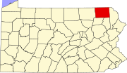 | |
| Townships |
| |
| Unincorporated communities | ||
| ||
This Pennsylvania-related article is a stub. You can help Wikipedia by expanding it. |