
Newington, New South Wales
| Newington Federal division(s) | Reid | ||||||||||||||
|---|---|---|---|---|---|---|---|---|---|---|---|---|---|---|---|
| |||||||||||||||
This article needs additional citations for verification. (January 2024) |
Newington is a western suburb of Sydney, in the state of New South Wales, Australia. It is 16 kilometres west of the Sydney central business district, in the local government area of City of Parramatta.
Newington is 2 km west of
History
The suburb of Newington took its name from the Newington Estate which was named by John Blaxland after his family estate in Kent, England.[2]
Aboriginal culture
Newington is situated on the traditional
European settlement
Within ten days arrival of the First Fleet in Australia, plat records were made of "The Flats", the extensive tidal wetlands at Homebush Bay. From 1788 to 1831, land grants in blocks of 100 to 10,000 acres (40 km2) were distributed to the European settlers from the Wanng-al clans holdings. Official County of Cumberland maps were annotated with the names and boundaries of the new land owners.
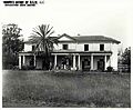
In 1807, John Blaxland acquired 520 hectares of land, originally reserve grants of Waterhouse, Shortland, Archer and Haslam. He named the estate Newington after his family estate in Kent, England. Blaxland established a series of salt pans on the banks of the Parramatta River and by 1827, was producing 8 tons of salt each week for the Sydney market. Blaxland also established a tweed mill, limekiln and flourmill. Newington House was completed in 1832 and St Augustine's Chapel in 1838.
In 1843, Blaxland mortgaged the property to the Australian Trust Company. The mortgage went unpaid at the time of his death in 1851. John Dobie purchased the property from the Trust Company to paid off the mortgage. The Blaxland family re-purchased the estate from Dobie in 1854 and offered it as security against a large loan. The property was transferred to the Official Assignee of the Insolvent Estate of Edward James Blaxland in 1860 and subsequently leased to the
Coal mining explorations were undertaken by Blaxland in 1841. He dug several six metre pits which gained the interest of the Australian Mining Company. The two parties reached agreement and, subsequently, undertook several unsuccessful explorations. In 1878, the City of Sydney Coal Company acquired the right to bore for coal at the site. The company drilled to 457 metres with no success. In 1855 the Australian Timber Company formed to exploit the timber stands in the Newington and surrounding areas. In the late 1870s and 1880s, Sydney's suburbs were expanding rapidly and it was hoped that the creation of a residential settlement between the large centres of Sydney and Parramatta would be a profitable exercise. This did not prove to be the case.
In 1878, John Wetherill registered a subdivision plan for the entire 520 hectare Newington Estate. This proposal comprised an extensive grid layout, of some 114 lots, which extended well into the mud flats and mangroves of Wentworth Bay and Homebush Bay. In 1906 and 1909, Wetherill further subdivided his property as Riverside Heights, with the first allotments sold in that year. It was hoped that the location of the subdivision in close proximity to the developing State
Early public use
The Newington Estate was first offered in 1874 to the Government for use as an Asylum for the Insane. The Government did not accept this offer, however in 1879, Government Architect James Barnet prepared a report on the suitability of the Newington estate for a Reformatory School for Boys. His report concluded that the site was suitable for a Boys Reformatory or a Benevolent Asylum for Aged Women. In September 1897 the Crown Solicitor confirmed that 5000 pounds would be paid to John Wetherill to acquire about 19 hectares of land, which included Newington House.
An Aged Women's Asylum was constructed to replace the existing asylum which was housed within the Immigrant Depot at the
Commercial areas
Newington Marketplace is an outdoor
Schools
- Newington Public School (NPS)
Gallery
-
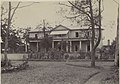 Newington House, Silverwater, c.1894.
 -
 Newington House Chapel, undated drawing.
 -
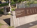 Olympic Village Memorial.
 -
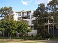 Former Athletes Village.
 -
 Newington
.jpg)


.jpg)
See also
References
- ^ Australian Bureau of Statistics (27 June 2017). "Newington (NSW) (State Suburb)". 2016 Census QuickStats. Retrieved 21 December 2017.
- ISBN 0-207-14495-8
- ^ a b Sydney Olympic Park Authority – Five Layers of History Archived 8 May 2006 at the Wayback Machine
External links
33°50′20″S 151°03′18″E / 33.839°S 151.055°E