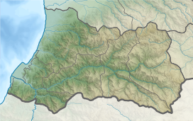
Nigali valley
| Nigali valley | |
|---|---|
| Turkish: Nigali Vadisi Georgian: ნიგალი, ნიგალის ხევი | |
| Geography | |
| Country | |
| Coordinates | 41°36′11″N 41°34′27″E / 41.60306°N 41.57417°E |
Nigali or the Nigali valley (
.History
d'Anville
's 1794 map identifying the then-Ottoman-controlled Livâne in Georgian name Liganis Khevi, "the Ligani valley".The land known as Nigal first appears as one of the districts of
Maçahel administratively dependent on it.[7]
In 1878, Nigali was part of the territory ceded by the Ottomans to the
Current division
Currently, the Turkish portion of Nigali comprises parts of the
Autonomous Republic of Adjara.[8]
See also
References
- ^ a b c Toumanoff, Cyril (1963). Studies in Christian Caucasian History, p. 439. Georgetown University Press.
- ISBN 3-88226-485-3
- ISBN 90-429-1318-5
- ^ Gugushvili, Andria (1936), "Ethnographical and Historical Division of Georgia". Georgica I, 2-3: 64.
- ^ (in Georgian and French) Wakhoucht (Brosset, Marie-Félicité, transl., 1842) Description géographique de la Géorgie ("Geographic description of Georgia"), p. 115. St. Petersbourg: A la typographie de l'Academie Impériale des Sciences.
- ^ (in Turkish) Sezen, Tahir (2006), Osmanlı yer adları (Alfabetik sırayla) ("Ottoman placenames. Alphabetic list"), p. 349. T.C. Başbakanlık Devlet Arşivleri Genel Müdürlüğü.
- ISBN 978-1-61719-099-5.
- ^ ISBN 978-9941-409-02-8.
- ISBN 0852552793.
- ^ (in Russian) Beridze, Eter (2009), Языковая ситуация в Нигальском ущелье ("Linguistic situation in the Nigali valley"). Vlast' i Obshchestvo 1: 71-82.


