
Nimmu–Padum–Darcha road
| Nimmu–Padum–Darcha road | |
|---|---|
Nimmu, Ladakh | |
| South end | Darcha, Himachal Pradesh |
| Location | |
| Country | India |
| States | Ladakh, Himachal Pradesh |
| Primary destinations |
|
| Highway system | |
Nimmu–Padum–Darcha road (NPDR) or Zanskar Highway
It is estimated that travel on this road will only take 10-12 hours to reach Leh from Manali, as opposed to the Leh-Manali highway taking almost
History


The regions of Lahul (Lha yul) and Spiti (sPi ti) were earlier parts of Ladakh.[9] They were attached to Zanskar.[10]
By 1847, when the British Raj arrived, they were separated from Ladakh and made a part of British Punjab. Thus the connections between Zanskar and Lahul and Spiti were partly severed.[11][a] Nevertheless, Lahaulis fought for the defence of Ladakh and Zanskar during the
In 1979, when Ladakh was divided into two districts by the state of
Following the Kargil War in 1999, the unfinished Chadar Road project was handed over to the Border Roads Organisation (BRO).[14][16] Trekkers on the Chadar trek (the frozen Zanskar River during winters) perceived the planned road as spoiling the wild and pristine environment. The central government questioned the state of Jammu and Kashmir in 2007 about the need for the road. The councillor of the Lingshed constituency replied that it was a "right" and a necessity for the development of the remote and backward villages of the region.[15]
In May 2023, the Border Roads Organisation reported that only a 15-kilometre stretch of the road remained incomplete.[3]
Route
The northern terminus is located at Nimmu in Ladakh, about 35 km (22 mi) east of Leh. The distance from Nimmu via Padum to the southern terminus at Darcha in Himachal Pradesh is 297 km (185 mi). The road consists of three major sections: Nimmu - Padum, Padum - Shingo La, Shingo La - Darcha.[17]
Nimmu terminus to Padum
This section needs expansion. You can help by adding to it. (May 2023) |
The total distance from Nimmu to Padum is 156 km (97 mi) on the proposed alignment. Only 15 km remained to be commissioned as of May 2023. This section covers the following towns/villages:[17]
-
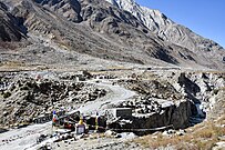
 Confluence of theStodand Zanskar near Padum. Road from Nimmu enters lower left, exits lower right to Padum.

Padum to Shingo La pass
From Padum, the road runs south along the Tsarap Lingti Chu river up to Purne, a distance of 53 km (33 mi).[18] At Purne, the road crosses the river and continues along the Kargiakh Chu, a left bank tributary of the Tsarap up to Lakhang Sumdo. This distance of 39 km (24 mi) has a gentle gradient.[19] Thereafter, the road climbs steeply from 4,460 m (14,630 ft) up to the Shingo La pass at 5,091 m (16,703 ft), covering a distance of 10.5 km (6.5 mi).[20] The total distance covered in this segment is 102.5 km (63.7 mi).
-
 Karsha Gompanorth of Padum
 -
 Road enters Padum valley along left bank of Tsarap
 -
 Tsarap gorge south from Padum
 -
 Road widening by blasting, Oct '22
 -
 Batch mixing plant for road work, near Amnu
 -
 Road winding down the right bank of the Tsarap towards Padum, Oct '22
 -
 Grey goral doe
 -
 Road under construction in Tsarap gorge, Oct '22
 -
 Phuktal Gompa near Purne
 -
 Bridge over the Tsarap at Purne, view from NW
 -
 Confluence at Purne
 -
 Kargyak, view from south
 -
 Road from Kargyak south to Gonbo Rangjon
 -
 Road from Shingo La down towards Lakang Sumdo


Shingo La to Darcha terminus
The newly-surfaced road (as of Oct '21) continues from the Shingo La pass down to the Darcha terminus. The road descends on the right bank of the Jankar Nala through Ramjak to Zanskar Sumdo, which has a helipad. The Jankar Nala enters a short gorge about 100 ft (30 m) deep. On the sides of the gorge is a Buddhist shrine to the deity
-
 Road under construction on right bank of Jankar Sangpo near Ramjak, Oct '20
 -
 Ramjak up to Shingo Ri, road left to centre, Oct '20
 -
 Road from right to centre, down Jankar Nala near Ramjak, Oct '20
 -
 Cyclists on under-construction road to Shingo La pass, Oct '20
 -
 Road construction near Zanskar Sumdo, Oct '20
 -
 Construction accident, Oct '20
 -
 Newly-surfaced road below Zanskar Sumdo
 -
 Gorge, bridge and shrine at Palden Lhamo, Oct '20
 -
 Jankar Nala gorge
 -
 Buddhist prayer stones
 -
 Chikka & Rarik villages, 6 km from the Darcha terminus, Oct '20


Inter-connectivity
This section needs expansion. You can help by adding to it. (May 2023) |
- Srinagar-Leh Highway at Nimmu
- Padum-Kargil Highway at Padum
- Leh–Manali Highway at Darcha
- "Sumdo-Nidder-Rhongo Road" (SNR Road), 64 km long road was completed by December 2023.[22]
Tourism
There are several ancient Buddhist monasteries (gompa), such as the Phuktal Monastery.
This road is also the route of famous Chadar trek ('ice sheet'), the 62 km long, 8 day (including acclimatization at Leh) snowy trek which starts and ends at the motorable Shingra Koma, the trek goes to Tsomo Paldar & Tibb cave to Nerak, and then traverse back to Tsomo Paldar.[23]
See also
- Leh-Manali Highway
- Shingo La
- Zanskar River
- Phuktal Monastery
Notes
- Treaty of Amritsarthrough a poorly documented transaction.
References
- ^ Demenge (2011), p. 80, note 59.
- ^ Demenge (2011), p. 26.
- ^ a b c Manjeet Singh Negi (6 September 2020). "Ground report: India's 'untraceable' road connecting Manali-Leh to allow hassle-free troop movement". India Today.
- ^ Bureau, BL New Delhi (26 March 2024). "BRO connects 298-km long Nimmu-Padam-Darcha road to Ladakh region". BusinessLine. Retrieved 4 April 2024.
- ^ Ghoshal, Devjyot (29 September 2020). "High road at Chilling: India builds Himalayan bridges and highways to match China". Reuters.
- ^ "Defence ministry clears the BRO tunnel under Shinkun La in Ladakh]". Hindustan Times. 19 May 2021.
- ^ "1,504.64 करोड़ की परियोजना के लिए 1,569 की बोली: HC ने BRO के 15 करोड़ जब्त करने के कदम को बरकरार रखा". jantaserishta. October 2023.
- ^ Ashiq, Peerzada (6 April 2024). "All-weather road gives a strategic fillip to Ladakh". The Hindu. The Hindu. Retrieved 7 April 2024.
- ISBN 978-0-8108-7984-3.
In the past, La dwags [Ladakh] sometimes included sBal ti yul (Baltistan); Zangs dkar [Zanskar]; Lahaul; Spiti; the Aksai Chin (Hin. Aksä'i cina; Ch. Akesai Qin); and mNga' ris [Ngari].
- ^ Fisher, Margaret W.; Rose, Leo E.; Huttenback, Robert A. (1963). Himalayan Battleground: Sino-Indian Rivalry in Ladakh. Praeger. pp. 18–19 – via Archive.org.
The Ladakhi chronicles state that the eldest son [of King Nyimagon], Pal-gyi-gön [Lhachen Palgyigon], received Ladakh and the Rudok area; the second son, Tra-shi-gön [Trashigon], Guge and Purang; while the third son, De-tsuk-gön [Detsukgon], was given Zanskar, Spiti and Lahul.
- ^ Cunningham, Alexander (1854). Ladak: Physical, Statistical, Historical. London: Wm. H. Allen and Co. p. 18 – via Archive.org.
Ladak is divided politically between Maharaja Gulab Sing and the East-India Company. To the former belong all the northern districts, to the latter only the two southern districts of Lahul and Spiti.
- S2CID 42308945.
- ^ Demenge (2013), pp. 52–53.
- ^ a b Demenge (2013), p. 52.
- ^ a b Demenge (2013), p. 53.
- ^ Demenge (2011), p. 80. "The road under construction passed into BRO hands in 2001, following the war and the recommendations of the Kargil Committee. It was already under construction for civilian purposes but the war demonstrated the need for all-year-round access to Ladakh to move troops and supplies to the Pakistani front, as opposed to the existing roads that were closed for five to six months in winter."
- ^ a b Vats, Rohit (23 August 2020). "Connecting Ladakh: India's growing road network to link borders with the mainland". India Today. Retrieved 20 May 2023.
- ^ OpenStreetMap contributors (5 November 2022). "Padum-Purne route" (Map). OpenStreetMap. OpenStreetMap. Retrieved 5 November 2022.[self-published source]
- ^ OpenStreetMap contributors (5 November 2022). "Purne-Shingo La route" (Map). OpenStreetMap. OpenStreetMap. Retrieved 5 November 2022.[self-published source]
- ^ OpenStreetMap contributors (5 November 2022). "Shingo La" (Map). OpenStreetMap. OpenStreetMap. Retrieved 5 November 2022.[self-published source]
- ^ OpenStreetMap contributors (5 November 2022). "Padum–Darcha route" (Map). OpenStreetMap. OpenStreetMap. Retrieved 5 November 2022.[self-published source]
- ^ YEAR-END DEADLINE SET FOR BRO TO COMPLETE 20 ROADS ALONG LAC AS STANDOFF WITH CHINA LOOKS INCREASINGLY IRREVERSIBLE, INDIAN DEFENCE NEWS, AUGUST 03, 2023.
- ^ Sumitran, Neha (1 April 2014). "On the Mighty Chadar, Everything Freezes but Tears". National Geographic Traveller India. Retrieved 2 February 2020.
Bibliography
- Demenge, Jonathan (2011). The Political Ecology of Road Construction in Ladakh (PDF). University of Sussex.
- Demenge, Jonathan (2013). "The Road to Lingshed: Manufactured Isolation and Experienced Mobility in Ladakh". Himalaya: The Journal of the Association for Nepal and Himalayan Studies. Vol. 32, no. 1. pp. 51–60.