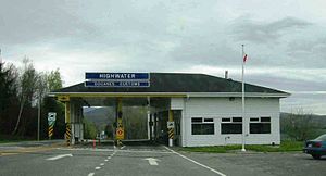
North Troy–Highwater Border Crossing
| North Troy-Highwater Border Crossing | |
|---|---|
 Canada Border Inspection Station at Highwater, Quebec | |
| Location | |
| Country | United States; Canada |
| Location |
|
| Coordinates | 45°00′26″N 72°24′58″W / 45.007292°N 72.415996°W |
| Details | |
| Opened | 1844 |
| US phone | (802) 988-2540 |
| Canadian phone | (450) 292-5995 |
| Hours | Open 24 hours (for non-commercial traffic into Canada) |
| Website | |
U.S. Inspection Station-North Troy, Vermont | |
MPS | U.S. Border Inspection Stations MPS |
| NRHP reference No. | 14000610 |
| Added to NRHP | September 10, 2014 |
The North Troy–Highwater Border Crossing connects the town of Highwater, Quebec with North Troy, Vermont on the Canada–US border. It is located at the meeting point of Vermont Route 243 and Quebec Route 243. Both stations are open 24 hours per day for non-commercial traffic; the Canadian station is open to commercial traffic on weekdays during business hours. The former US station facilities, dating to the 1930s, are listed on the National Register of Historic Places.
Setting
This border crossing, one mile east of the
Canadian station
Canada first established a Customs operations for this crossing in 1844, when it opened an office four miles north in the town of Potton. In 1933, the office was moved to its present location at the border.[2] The US border station was constructed shortly thereafter. Canada rebuilt its station in 1966.
United States station

The United States station was built in 2009, replacing a facility built in 1937. The 1937 station's main building, which still stands about 150 feet (46 m) south of the current facility, is one of ten surviving 1930s station buildings in Vermont, and was listed on the National Register of Historic Places in 2014 for its architecture and historic significance. It was the first formal border station built on this site, as part of a program by the United States government to improve border security due to increases in the use the automobile for travel, illegal immigration, and smuggling occasioned by Prohibition.[3]
See also
- List of Canada–United States border crossings
- National Register of Historic Places listings in Orleans County, Vermont
References
- ^ "Chapter 2: The 45th Parallel". United Divide: A Linear Portrait of the USA/Canada Border. The Center for Land Use Interpretation. Winter 2015.
- ^ Bailey, Merton (1982). Border Crossings of Potton Township.
- ^ "NRHP nomination for U.S. Inspection Station-North Troy, Vermont" (PDF). National Park Service. Retrieved 2017-01-13.

