
Nyzhnie Synovydne
Nyzhnie Synovydne
Нижнє Синьовидне | |
|---|---|
UTC+3 (EEST) | |
| Postal code | 82615 |
| Area code | +380 3251 |
| Website | село Нижнє Синьовидне (Ukrainian) |
Nyzhnie Synovydne (Ukrainian: Ни́жнє Синьови́дне, Polish: Synowódzko Niżne) is a village (selo) in Stryi Raion, Lviv Oblast, of Western Ukraine. It belongs to Skole urban hromada, one of the hromadas of Ukraine.[1] The population of the village is about 1,113 people and Local government is administered by Nyzhnosynovydnenska village council.[2]
Geography
The village is located in the river valley where the two rivers merge into one —
Area of the village totals is 1,63 km2 and is located along the Highway M06 (Ukraine) (
History
The village is known from the 13th century, although the official founding date of village is 1691.[3]
In ancient times through the village was a trade route from Kievan Rus' to Hungary.
Until 18 July 2020, Nyzhnie Synovydne belonged to Skole Raion. The raion was abolished in July 2020 as part of the administrative reform of Ukraine, which reduced the number of raions of Lviv Oblast to seven. The area of Skole Raion was merged into Stryi Raion.[4][5]
Attractions
The village has two sights of architecture Skole district:[6]
- Assumption of the Virgin Mary church (wood, 1803) (1416 / 1)
- Assumption of the Virgin Mary church bell tower 18th century (wood). (1416 / 2)
Gallery
-
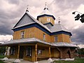 Assumption of the Virgin Mary church
 -
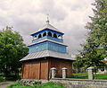 Assumption of the Virgin Mary church bell tower

.JPG)
References
- ^ "Сколевская городская громада" (in Russian). Портал об'єднаних громад України.
- ^ Nyzhnosynovydnenska village council Archived 2015-01-26 at the Wayback Machine
- ^ Nyzhnye Synyovydne village: street map, photos
- ^ "Про утворення та ліквідацію районів. Постанова Верховної Ради України № 807-ІХ". Голос України (in Ukrainian). 2020-07-18. Retrieved 2020-10-03.
- ^ "Нові райони: карти + склад" (in Ukrainian). Міністерство розвитку громад та територій України.
- ^ Пам'ятки архітектури Сколівського району (in Ukrainian)
External links
- Населенні пункти Сколівського району - Нижнє Синьовидне (in Ukrainian)
- village Nyzhnie Synovydne
- weather.in.ua
Literature
- Ukrainian: Історія міст і сіл УРСР : Львівська область. – К. : ГРУРЕ, 1968 р. Page 717
| Cities | Urban-type settlements | ||
|---|---|---|---|
| Villages |
| ||
This article about a location in Lviv Oblast is a stub. You can help Wikipedia by expanding it. |