
Odanah, Wisconsin
Odanah, Wisconsin
Oodena | ||
|---|---|---|
FIPS code 55-59450[4] | | |
| GNIS feature ID | 1570746[2] | |
Odanah (
Odanah is the cultural and administrative center of the
For statistical purposes, the U.S. Census Bureau distinguishes Odanah from New Odanah, which has most of the community's population. In local parlance, the names are used interchangeably. Official state and county maps from the Wisconsin DOT only show Odanah.[6][7]
History
A post office called Odanah has been in operation since 1855.[8] The name is from an Ojibwe language word, now spelled oodena, meaning "village."[9]
A 1960 flood led to the establishment of the Bad River Housing Authority, which relocated thousands of Odanah residents to higher ground a few miles down the road, away from the flood plain.[10]
Geography
Odanah is located at 46°36′9″N 90°40′57″W / 46.60250°N 90.68250°W (46.602594, -90.682582),[11] along the Bad River.[12]
According to the United States Census Bureau, the CDP has a total area of 2.77 square miles (7.18 km2), of which 2.62 square miles (6.78 km2) is land and 0.16 square miles (0.41 km2) is water.[1]
Demographics
As of the
There were 94 households, out of which 37.2% had children under the age of 18 living with them, 18.1% were married couples living together, 39.4% had a female householder with no husband present, and 30.9% were non-families. 26.6% of all households were made up of individuals, and 10.6% had someone living alone who was 65 years of age or older. The average household size was 2.70 and the average family size was 3.23.
In the CDP, the population was spread out, with 36.6% under the age of 18, 8.7% from 18 to 24, 27.2% from 25 to 44, 20.5% from 45 to 64, and 7.1% who were 65 years of age or older. The median age was 31 years. For every 100 females, there were 82.7 males. For every 100 females age 18 and over, there were 64.3 males.
The median income for a household in the CDP was $25,156, and the median income for a family was $24,125. Males had a median income of $25,000 versus $19,063 for females. The
Notable people
- Justus Smith Stearns, prominent businessman in this community.
Images
-
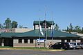 Post office
 -
 Sign on U.S. 2
 -
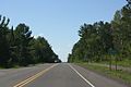
 Looking north in Odanah
 -
 Looking west at the sign for Odanah
 -
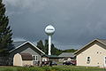 Water tower
 -
 St. Mary Catholic Church


See also
- New Odanah, Wisconsin
- Diaperville, Wisconsin (sometimes called "Old Odanah")
References
- ^ a b "2020 Gazetteer Files". census.gov. U.S. Census Bureau. Retrieved July 14, 2022.
- ^ a b "US Board on Geographic Names". United States Geological Survey. October 25, 2007. Retrieved January 31, 2008.
- ^ a b "2020 Decennial Census: Odanah CDP, Wisconsin". data.census.gov. U.S. Census Bureau. Retrieved July 14, 2022.
- ^ a b "U.S. Census website". United States Census Bureau. Retrieved January 31, 2008.
- ^ Rivero, Nicolas (August 25, 2017). "The Smallest Town in Each of the 50 States". Mental Floss. Retrieved June 25, 2018.
- ^ "Ashland County Map" (PDF). Wisconsin Department of Transportation. Retrieved July 14, 2022.
- ^ "Official Wisconsin highway map". Wisconsin Department of Transportation. Retrieved July 14, 2022.
- ^ "Ashland County". Jim Forte Postal History. Retrieved March 24, 2015.
- ISBN 978-1-4381-2671-5.
- ^ Hersher, Rebecca (August 15, 2018). "Wisconsin Reservation Offers A Climate Success Story And A Warning". NPR.org. Retrieved December 1, 2019.
- ^ "US Gazetteer files: 2010, 2000, and 1990". United States Census Bureau. February 12, 2011. Retrieved April 23, 2011.
- ISBN 0-89933-247-1
| Communities |  | |
|---|---|---|
| Related Geographic Aspects |
| |
| Local Native American Tribes | ||
 | ||||
Village | ||||
Towns | ||||
| CDPs | ||||
| Other communities |
| |||
| Indian reservation | ||||
| Footnotes | ‡This populated place also has portions in an adjacent county or counties | |||
| ||||