
Owls Head Light
 | |
 | |
| Location | Owls Head, Maine |
|---|---|
| Coordinates | 44°05′30″N 69°02′38″W / 44.09167°N 69.04389°W[1] |
| Tower | |
| Constructed | 1825 |
| Foundation | Granite |
| Construction | Brick |
| Automated | 1989 |
| Height | 9 m (30 ft) |
| Shape | Cylindrical |
| Markings | White with black lantern |
| Heritage | National Register of Historic Places listed place |
| Fog signal | Horn: 2 every 20s |
| Light | |
| First lit | 1825 |
| Focal height | 100 feet (30 m) |
| Lens | 4th order Fresnel lens[2] |
| Range | 16 nautical miles (30 km; 18 mi) |
| Characteristic | Fixed white |
Owls Head Light Station | |
 | |
| Nearest city | Owls Head, Maine |
| Area | 3 acres (1.2 ha) |
| Built by | Jeremiah Berry; Green & Foster |
| NRHP reference No. | 78000183 |
| Added to NRHP | January 18, 1978 |
The Owls Head Light is an active aid to
History
The town of Owls Head is located south of Rockland, and includes an eponymous peninsula that projects northeast into Penobscot Bay, with its tip roughly east of downtown Rockland. The light station is located at the eastern tip of this peninsula. The light station was established in 1825 with the construction of a round, rubblestone tower by Jeremiah Berry and Green & Foster.
In 1854, a keeper's house was built separately from the lighthouse. The cottage now serves as the headquarters of the American Lighthouse Foundation. A fourth order Fresnel lens was installed in 1856. A generator house and an oil storage building were added in 1895.
Renovations carried out in 2010 saw the tower restored to its 1852 appearance. In addition to repainting the tower, repairs were done to the bricks, the lantern's ironwork and windowpanes, and the parapet's floor.[9]
Gallery
-
 Postcard view ca. 1930s
 -
 The hill where the tower sits
 -
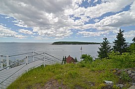 The view from the base of the tower
.jpg)


See also
References
- ^ "Owls Head". Geographic Names Information System. United States Geological Survey, United States Department of the Interior.
- ^ a b "Fresnel Lenses Still in Operation" (PDF). U.S. Coast Guard. December 2008. Retrieved June 22, 2015.
- ^ Light List, Volume I, Atlantic Coast, St. Croix River, Maine to Shrewsbury River, New Jersey (PDF). Light List. United States Coast Guard. 2017. p. 36.
- ^ "Historic Light Station Information and Photography: Maine". United States Coast Guard Historian's Office. December 21, 2016. Archived from the original on May 1, 2017.
- ^ Rowlett, Russ (April 5, 2017). "Lighthouses of the United States: Southern Maine". The Lighthouse Directory. University of North Carolina at Chapel Hill.
- ^ "Owls Head Lighthouse". American Lighthouse Foundation. Retrieved June 22, 2015.
- ^ "Owls Head State Park". Department of Agriculture, Conservation and Forestry. Retrieved July 26, 2014.
- ^ a b c Flaherty, Michael F. (January 18, 1978). "Owls Head Light Station". National Register of Historic Places Nomination Form. National Park Service. Retrieved June 22, 2015.
- ^ a b "Owls Head Lighthouse". Lighthousefriends. Retrieved June 22, 2015.
External links
- Owls Head State Park Department of Agriculture, Conservation and Forestry

| Topics | |
|---|---|
| Lists by state |
|
| Lists by insular areas | |
| Lists by associated state | |
| Other areas | |
| Related | |
| Authority control databases: Geographic |
|
|---|