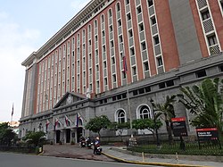
Palacio del Gobernador
| Palacio del Gobernador | |
|---|---|
 Facade of the Palacio del Gobernador | |
 | |
| General information | |
| Town or city | Manila |
| Country | Philippines |
| Current tenants | Commission on Elections[1] Intramuros Administration |
| Completed | 1976 |
| Design and construction | |
| Architect(s) | Otilio Arellano |
| Designations | NHCP marked structure |
| Website | |
| www | |
The Palacio del Gobernador (transl. Governor's Palace) is a government building located in
Home Development Mutual Fund National Capital Region Office. It also previously housed the Bureau of the Treasury until it relocated across Plaza de Roma to the Ayuntamiento de Manila.[when?
]
The site of the present building was where the former residence of the
Rafael de Echagüe y Bermingham moved to Malacañang after the earthquake.[3][4] The Malacañang Palace then became the governor-general's official residence.[5]
The building's exterior was used in the
Brazilian Carnaval
parade.

References
- ^ Esmaquel II, Paterno R. (December 1, 2017). "Comelec faces eviction from Palacio del Gobernador". Rappler. Retrieved July 22, 2021.
- ISBN 978-971-07-2276-1. Retrieved July 22, 2021.
- ^ Medina, Marielle (June 3, 2020). "Did You Know: Palacio del Gobernador damaged in 1863 quake". INQUIRER.net. Retrieved July 22, 2021.
- ^ East Asian Cultural Studies (in Spanish). Centre for East Asian Cultural Studies. 1970. Retrieved July 22, 2021.
- ^ Former Palace of the Governors General [sic] (Marker on building facade). Palacio del Gobernador in Intramuros: Historical Research and Markers Committee. 1936.
14°35′30″N 120°58′21″E / 14.5916°N 120.9725°E

