
Palashipara
Palashipara | |
|---|---|
Village | |
 Palashipara Location in West Bengal  Palashipara Palashipara (India) | |
| Coordinates: 23°47′0″N 88°27′0″E / 23.78333°N 88.45000°E | |
| Country | |
| State | West Bengal |
| District | Nadia |
| Population (2011) | |
| • Total | 10,693 |
| Pin | 741155 |
Palashipara, is a village in the
.History
At the time of the
Geography


5miles
River
CT: census town, R: rural/ urban centre.
Owing to space constraints in the small map, the actual locations in a larger map may vary slightly
Location
Palashipara is located at 23°47′0″N 88°27′0″E / 23.78333°N 88.45000°E.
Area overview
Nadia district is mostly alluvial plains lying to the east of Hooghly River, locally known as Bhagirathi. The alluvial plains are cut across by such distributaries as Jalangi, Churni and Ichhamati. With these rivers getting silted up, floods are a recurring feature.[4] The Tehatta subdivision, presented in the map alongside, is topographically part of the Nadia Plain North. The Jalangi River forms the district/ subdivision border in the north-western part and then flows through the subdivision. The other important rivers are Mathabhanga and Bhairab. The eastern portion forms the boundary with Bangladesh.[5] The subdivision is overwhelmingly rural. 97.15% of the population lives in the rural areas and 2.85% lives in the urban areas.[6]
Note: The map alongside presents some of the notable locations in the subdivision. All places marked in the map are linked in the larger full screen map. All the four subdivisions are presented with maps on the same scale – the size of the maps vary as per the area of the subdivision.
Demographics
According to the
Civic administration
Police station
Palashipara police station serves Tehatta II subdivision.[8]
CD block HQ
The headquarters of Tehatta II CD block are located at Palashipara.[9]
Education
There are two high schools at Palashipara. Palashipara Mahatma Gandhi Smriti Vidyapith known as MGS vidyapith is situated here. another Higher Secondary school Palashipara Mahatma Gandhi Smriti Balika Vidyalaya is the schools for girls', providing 10+2 education to the locals. There are few primary schools in the locality.[10]
Transport
Palashipara is connected by bus with district headquarters
Palashipara picture gallery
-
 Dwijendralal Bridge over the Jalangi river, Palashipara
 -
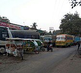 Palashipara bus terminus
 -
 Palashipara Mahatma Gandhi Smriti Vidyapith


References
- ^ Lokesh Ch Biswas (2016). Tehatta Mahakumar Nilkuthi (Bengali). Chakdah: Monokothan, yearly little magazine. p. 8.
- ISBN 978-984-8116-00-5.
- ^ Industries, Bengal (India) Department of (1929). Report on the Survey of Cottage Industries in Bengal. Bengal Secretariat Book Depot.
- ^ Gangopadhyay, Basudev, Paschimbanga Parichay, 2001, (in Bengali), p. 70, Sishu Sahitya Sansad
- ^ "District Census Handbook, Nadia, 2011, Series 20, Part XII A" (PDF). Pages 13,14. Directorate of Census Operations, West Bengal. Retrieved 15 October 2020.
- ^ "District Statistical Handbook 2014 Nadia". Table 2.2, 2.4(a). Department of Planning and Statistics, Government of West Bengal. Retrieved 15 October 2020.
- ^ "2011 Census – Primary Census Abstract Data Tables". West Bengal – District-wise. Registrar General and Census Commissioner, India. Retrieved 18 May 2017.
- ^ "Nadia Gets Its 22nd Police Station In Palashipara". Retrieved 17 December 2018.
- ^ "District Census Handbook: Nadia, Series 20 Part XII A" (PDF). Map of Nadia with CD Block HQs and Police Stations (on the fourth page). Directorate of Census Operations, West Bengal, 2011. Retrieved 2 May 2017.
- ^ "West Bengal Board of Secondary Education". wbbse.org. Retrieved 19 March 2017.
- ^ "পলাশিপাড়ার সেতু". anandabazar.com. Retrieved 17 December 2018.
| ||||||||||
|---|---|---|---|---|---|---|---|---|---|---|
| Cities, municipal and census towns |
|  | ||||||||
| Locations other than cities and towns |
| |||||||||
| Related topics | ||||||||||