
Kalyani, West Bengal
This article has multiple issues. Please help improve it or discuss these issues on the talk page. (Learn how and when to remove these template messages)
|
Kalyani | |
|---|---|
City in India | |
Kalyani | |
| Website | www |
Kalyani is a
During the period of
Kalyani has a dedicated industrial zone including
History
Kalyani, located in Nadia district in the state of West Bengal, is a relatively young town. During the
The military garrison town was named after the then-sitting President of the United States Franklin D. Roosevelt as "Roosevelt Town" or "Roosevelt Nagar", with "nagar" meaning "town" in many Indo-Aryan languages, including Bengali. Hangars and other reminders of the airfield are still visible in the 'A' Block and some areas around Kalyani University, whose buildings were built on or over the runways.[6] After World War II, the United States Army Air Force left the base, and the airfield and hangars went into disuse.
The development of modern Kalyani is credited to the former
In 1995, the Kalyani Municipality was established, which has been crucial in the development of infrastructure in Kalyani.[6] In 2014, Kalyani was selected as a candidate for a "Smart City" project. Although this project has since been abandoned by the State Government.
Geography and urban structure
Kalyani is located in the
Kalyani is a planned city, having underground drainage systems, tree-lined avenues, community parks, paved roads intersecting each other at 90-degree angle. The city itself is divided into four blocks — Block A, Block B, Block C and Block D, which are further divided into sub-blocks. Block A and B are mostly residential in character with commercial markets. Main Post Office, Industrial Training Institute, Government offices and the Public Library along with offices of major Banks are situated in Block B. Whereas the Kalyani main station, State General Hospital, Medical college are situated in A Block. Block C and Block D are located to the north of Kalyani Simanta branch line. Block C is reserved for institutional use and is largely occupied by the
In June 2015, the Government of West Bengal declared establishment of an "Analytics City" name Samriddhi in Kalyani, besides Uditi Government Housing Project which was projected to attract investments of more than Rs 3,000 crore in next three years.[9] In the first phase, being developed over 52 acres off Kalyani Expressway, the hub will accommodate academic, residential and commercial centers apart from real estate projects.[9]
New Kalyani Block consists of 7 Gram Panchayats: Saguna, Madanpur - 1, Madanpur - 2, Chanduria - 2, Simurali, Kanchrapara, and Sarati.
Police station
Kalyani police station under Ranaghat Police District has jurisdiction over Kalyani, Gayespur municipal towns and Saguna Panchayat areas.[10][11] The total area covered by the police station is 64 km2 and the population covered is 201,871 (2001 census).[12]
Demographics
| Year | Pop. | ±% |
|---|---|---|
| 1961 | 4,616 | — |
| 1971 | 18,310 | +296.7% |
| 1981 | 39,257 | +114.4% |
| 1991 | 57,648 | +46.8% |
| 2001 | 85,503 | +48.3% |
| 2011 | 100,575 | +17.6% |
| Source: Government of India[13] | ||
As of
Civic administration and utility services
The town is within the
Kalyani quickly registered itself as a self-sufficient township. Its gradual development continued as a notified area. In 1995, it was upgraded to a municipality.[16]
Transport
Kalyani is connected directly with Kolkata through
Education

Kalyani's schools are run by the state government or private institution. Bengali and English are the primary languages of instruction.[17] Schools in Kalyani follow the "10+2+3" plan. After completing their secondary education, students typically enroll in schools that have a higher secondary facility and are affiliated with the West Bengal Council of Higher Secondary Education, the ICSE, or the CBSE.[17] They usually choose a focus on liberal arts, business, or science. Vocational programs are also available.[17] Among the schools in Kalyani whose mode of instruction is English include Julien Day School, Jawahar Navodaya Vidyalaya, Springdale High School, Garden High School, IISER Kolkata Campus (in Mohanpur); while Kalyani University Experimental High School and Pannalal Institution instructs in Bengali.

Kalyani has two universities —
The main campus of the
Healthcare

Healthcare system in Kalyani consists of both government and private healthcare facilities. The Army hospital established during WWII by the American and British alliance was the first hospital in Kalyani. Later former Chief Minister of West Bengal Dr B C Roy converted it into a hospital for tuberculosis patients in the 1960s, currently known as Netaji Subhash Sanatorium. Jawaharlal Nehru Memorial Hospital, a 500-bed hospital, is one of the major hospitals in the town. A medical college, College of Medicine & JNM Hospital, established in 2009, which acts as the University college of West Bengal University of Health Sciences.[18] Gandhi Memorial Hospital has a dedicated cardiac surgery and cardiology department.[19] ESI Hospital provides healthcare to workers under Employees' State Insurance MB Scheme. There is also a branch of National Institute of Homoeopathy with 25 acres herb garden which was established in 1975.[citation needed]
In June 2014, the central government gave in-principle clearance for setting up All India Institute of Medical Sciences, Kalyani at Basantapur village in the Saguna Panchayat in Kalyani.[20] This project was shifted from earlier plans of setting up the AIIMS at Raiganj because of problems in land acquisition. The project was completed in 2019.[21]
Sports
Gallery
-
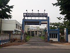 College of Medicine & JNM Hospital
 -
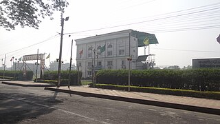
 Kalyani Municipality
 -
 A Sealdah bound train at Kalyani railway station
 -
-
 Bengal Cricket Academy Ground, Kalyani
 -
 Kalyani Picnic Garden
 -
 A-B Connector, Kalyani
 -
 AIIMS in Kalyani
 -
 Kalyani Head Post Office
 -
 Kalyani Sub Divisional Court


References
- ^ "Kalyani City". sudawb.org. Retrieved 25 November 2020.
- ^ a b c d "Cities having population 1 lakh and above" (PDF). Census of India, Government of India. Retrieved 2 November 2011.
- ^ "52nd Report of the Commissioner for Linguistic Minorities in India" (PDF). Nclm.nic.in. Ministry of Minority Affairs. p. 85. Archived from the original (PDF) on 25 May 2017. Retrieved 28 August 2019.
- ^ a b "Fact and Figures". Wb.gov.in. Retrieved 28 August 2019.
- ^ "CAB's first cricket academy inaugurated". The Times of India. 4 September 2011. Archived from the original on 21 August 2013. Retrieved 8 May 2013.
- ^ a b c d e Bhattacharya, Bitan (13 January 2015). "সামরিক শহরের স্মৃতি নিয়ে বেড়ে উঠেছে কল্যাণী". Ananda Bazar Patrika. Retrieved 1 August 2015.
- ^ Das, Diptendra; Chattopadhyay, B.C. (17–19 December 2009). Characterization of soil over Kolkata municipal area (PDF). Indian Geotechnical Conference. Vol. 1. Guntur, India. pp. 11–12. Retrieved 19 November 2012.
- ^ UNDP. Archived from the original(PDF) on 19 May 2006. Retrieved 23 August 2006.
- ^ a b "West Bengal to develop analytics-themed city near Kalyani township". Economic Times. 19 June 2015. Retrieved 25 June 2015.
- ^ "District Statistical Handbook 2014 Nadia". Table 2.1. Department of Statistics and Programme Implementation, Government of West Bengal. Retrieved 7 October 2020.
- ^ "Nadia District Police". Police Unit. West Bengal Police. Archived from the original on 28 May 2017. Retrieved 17 May 2017.
- ^ "Kalyani Police Station Details". Nadia Police. Archived from the original on 29 March 2016. Retrieved 17 May 2017.
- ^ "Census Tables". censusindia.gov.in. Retrieved 6 January 2024.
- ^ "Census of India 2001: Data from the 2001 Census, including cities, villages and towns (Provisional)". Census Commission of India. Archived from the original on 16 June 2004. Retrieved 1 November 2008.
- ^ "Press Note, Delimitation Commission" (PDF). Assembly Constituencies in West Bengal. Delimitation Commission. pp. 4, 23. Retrieved 18 April 2009.
- ^ "Category, Year of Establishment, Area, SC, ST and total population in ULBs in West Bengal" (PDF). Department of Municipal affairs, Government of West Bengal. Retrieved 1 March 2009.[permanent dead link]
- ^ a b c "Annual Report 2007–2008" (PDF). Department of School Education, Government of West Bengal. p. 69. Retrieved 10 December 2011.
- ^ "College of Medicine & J.N.M.Hospital". West Bengal University of Health Sciences. Archived from the original on 23 May 2012. Retrieved 10 May 2012.
- ^ "CM shows off state's sound cardiac care". The Times of India. 5 December 2003. Archived from the original on 13 November 2013. Retrieved 23 May 2013.
- ^ "Centre approves AIIMS-like project at Kalyani in WB". Business Standard India. Press Trust of India. 25 March 2015. Retrieved 27 August 2017.
- ^ Debashis Konar. Centre gives nod for AIIMS in Kalyani. Times of India. 21 June 2014.
External links
 Media related to Kalyani, West Bengal at Wikimedia Commons
 Kalyani, West Bengal travel guide from Wikivoyage
- Kalyani Municipality Website
| ||||||||||
|---|---|---|---|---|---|---|---|---|---|---|
| Cities, municipal and census towns |
|  | ||||||||
| Locations other than cities and towns |
| |||||||||
| Related topics | ||||||||||