
Pallister
Pallister is an area in the
The area, made up of mostly council houses, has developed a reputation over the years for crime and anti-social behaviour, although Middlesbrough Council and Erimus Housing have made it a target to reduce crime rates.
-
 Pallister Park
 -
 Pallister Park field


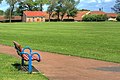
It is also known as Pallister Park or Pally Park because of the public park located at the northern edge of the area.
Education
There are two primary schools in the area - Pallister Park Primary School, on Gribdale Road and Corpus Christi RC Primary School, on Cargo Fleet Lane. There is a secondary school, Unity City Academy, towards the south of the area. The road that flows through the main area is Homerton Road and Cranmore Road.
Famous people from Pallister
- Stewart Downing Footballer
- Ged Parsons[3] Comedy writer on television programmes such as 'Have I Got News For You', 'Mock the Week', etc.
- John McKitterick[4] - Head of Fashion Design Department, Kingston University
- Sean Davies - Footballer[5]
References
- ^ "Middlesbrough ward population 2011". Retrieved 22 July 2015.
- ^ "Berwick Hills & Pallister - E05009855 Ward". Retrieved 12 July 2021.
- ^ Ged Parsons (Casarotto)
- ^ John McKitterick - Kingston University
- Sean Graham Davies
External links
- Map sources for Pallister
54°33′49″N 1°12′02″W / 54.56359°N 1.20043°W