
Parsau
Parsau | |
|---|---|
 Coat of arms | |
Location of Parsau within Gifhorn district  | |
 Parsau  Parsau | |
| Coordinates: 52°32′N 10°52′E / 52.533°N 10.867°E | |
| Country | Germany |
| State | Lower Saxony |
| District | Gifhorn |
| Municipal assoc. | Brome |
| Subdivisions | 4 |
| Government | |
| • Mayor | Kerstin Keil (CDU) |
| Area | |
| • Total | 29.33 km2 (11.32 sq mi) |
| Elevation | 62 m (203 ft) |
| Population (2022-12-31)[1] | |
| • Total | 1,983 |
| • Density | 68/km2 (180/sq mi) |
| Time zone | UTC+01:00 (CET) |
| • Summer (DST) | UTC+02:00 (CEST) |
| Postal codes | 38470 |
| Dialling codes | 05368 |
| Vehicle registration | GF |
Parsau is a municipality in the district of Gifhorn, in Lower Saxony, Germany. The Municipality Parsau includes the villages of Ahnebeck, Croya, Kaiserwinnkel and Parsau.
-
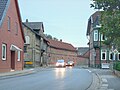 The main street
 -
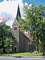 The Lutheran church
 -
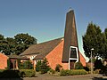
 The Baptist church
 -
 The catholic church
 -
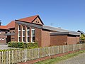
 The former station


References
- Landesamt für Statistik Niedersachsen.

| International | |
|---|---|
| National | |
| Geographic | |