
Paseo de la Reforma
 Paseo de la Reforma as seen from Chapultepec Castle | |
| Length | 14.7 km (9.1 mi) |
| Location | Mexico City, Mexico |
| Nearest metro station | Auditorio, Garibaldi / Lagunilla, Hidalgo |
| Coordinates | 19°26′04″N 99°09′07″W / 19.43444°N 99.15194°W |
.jpg)
Paseo de la Reforma (literally "Promenade of
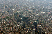
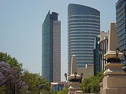
It is now home to many of Mexico's tallest buildings such as the
Profile
Today, the Reforma is filled with tourist attractions, luxurious restaurants and hotels, office buildings, public art exhibitions, and new construction.
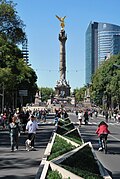
Reforma has become a traditional place for the Mexicans to celebrate or protest. Most protest rallies commonly go along Reforma from the Angel of Independence to the Zócalo, or from the Zócalo to Los Pinos. Many parades also make their way through Reforma. The Angel of Independence roundabout is a traditional place for the celebration of the victories of the national football team, mostly during World Cups.
History
19th century

.jpg)
In 1864, during the
Two such projects were begun, one on Avenida Chapultepec, which was never completed, and the other to connect the city center with Chapultepec Castle. The latter was named Paseo de la Emperatriz, in honor of Empress Carlota, and was to be for the personal use of the Emperor.[3] Austrian mining engineer Alois Bolland was put in charge of the project and designed what was finally implemented.
The route and the construction of six boulevards radiating outward from the Zócalo, Mexico City's main square, was assigned to a committee of prominent architects (Carl Gangolf and Ramón Rodríguez Arangoiti) and artists (Felipe Sojo, Miguel Noreña, Santiago Rebull). The committee's original proposal planned. However, this would have required the demolition of large portion of the buildings in the city, as happened in Paris. The committee decided instead to begin the boulevard at what was then the edge of the city, 1.5 km west of the Zócalo, where Avenida Bucareli meets Avenida Juárez and where the Equestrian statue of Charles IV of Spain stood. From that location, the Paseo's route led to the bottom of the royal residential area at Chapultepec Castle, where it connected to the road circling up to the castle at the top of the hill.[4][5]
.jpg)
The Austrian engineers Bolland and Ferdinand van Rosenzweig were assigned to construct the boulevard. Originally it included two vehicle paths, 9 meters wide each, a central island 1.5 meters wide, and two pedestrian side paths, each 9 meters wide, resplendent with ornamental plants and trees. The city government and the owners of the agricultural land along the route opposed the plan. Reasons included the fragility of the land, which was reclaimed lake bed of Lake Texcoco, and that the saltiness of the soil would supposedly not support the lush vegetation required.

Despite opposition, the project continued. After a competition, it was assigned to the brothers Juan and Ramón Agea under the supervision of the Ministry of Development, Colonization, Industry and Commerce, headed by Luis Robles Pezuela. Of the original 3.15 km-long project, only one part was completed between 1864 and 1865, a road 20 meters wide, which was enormous for those days, without a central median, only a few areas on the side reserved for horses to rest. There were practically no buildings along the boulevard and sidewalks were not considered necessary.[4][5]
The Paseo did not include bridges or similar constructions to cross the canals and rivers which then flowed near what is now Colonia Tabacalera (then Hacienda de la Teja). The Paseo was at this time for the exclusive use of the imperial court, a policy enforced by a dedicated police force. At the time, people with horses or horses and carriages, promenaded along the Paseo de Bucareli (today Avenida Bucareli between Avenidas Juárez and Chapultepec.[4][5]
After the downfall of the Second Mexican Empire and the restoration of the republic in 1867, the Paseo de la Emperatriz was renamed Calzada Degollado in honor of General Santos Degollado and then in 1872 Paseo de la Reforma.[4][5][6]
On February 17, 1867 the Paseo officially opened to the public while work continued on it. By 1870 it had tree-lined pedestrian medians between "el Caballito" and the Palm Tree Roundabout, carried out by the Ministry of Development under Francisco P. Herrera. Between 1872 and 1876 an eight-meter bridge was built at Hacienda de la Teja and the pedestrian medians were completed all the way to Chapultepec. Eucalyptus and ash trees and willows were planted and four monumental roundabouts (glorietas) were built between the Palm Tree Roundabout and Avenida Juárez. In 1872 the boulevard was renamed Paseo de la Reforma. On its flanks, upscale subdivisions were built, Colonia Americana – today Colonia Juárez, and Colonia Cuauhtémoc. The French style of the area was epitomized at the time by frequent comparisons of Paseo de la Reforma to the Champs Elysées in Paris.[4][5]
Liberal general Porfirio Díaz seized president power in 1876 after having distinguished himself as a leader in the war against the French Intervention. As president, he fully supported the embellishment of the Paseo de la Reforma with statuary representing Mexico's heroes through its history, creating "monuments worth of the culture of this city, and whose sights remind of the heroism with which the nation fought against the Conquest in the sixteenth century and for the Independence and Reform in the present."[7] Initially, liberal General Vicente Riva Palacio, grandson of liberal leader of independence Vicente Guerrero, was involved in projects to raise the capital's profile when he served as Díaz's Minister of Development (fomento) (1876-1879). As part of the centralizing impetus of Díaz's government, the Paseo de la Reforma was to include statues of heroes and cultural eminences of Mexico's constituent states, although some state leaders objected to the reassertion of traditional Mexico City's power.[8]
The major intersections of the broad avenue were traffic roundabouts (glorietas) where statues commemorating persons and events in Mexican history were placed over the next decades. The first monument on the Paseo was the
Renovation

In 2003 Mexico City's government started a renewal program for Paseo de la Reforma. It included the maintenance of the existent gardens and the creation of new ones, the intensive cleaning and sweeping of streets and sidewalks, the construction of new pink quarry sidewalks and benches, the creation of access bays in the Zoo, lake and Modern Art Museum for touristic and school buses, the installation of new lighting, the moving of the monument to Cuauhtémoc to the crossing of Avenida de los Insurgentes and Paseo de la Reforma, the construction of prism shaped concrete structures in the median which also have plants and flowers, the promotion of Reforma as a cultural walk organizing different expositions along the avenue sidewalks, and the maintenance of the monuments, sculptures and fountains. Also, a touristic route that goes from Chapultepec Park to the Historic Center along Reforma was established by a double deck bus called Turibus.
With the renewal project, new life has come to the avenue. It has become a main attraction of the city and the most expensive one to build on. However, after many of Mexico City's banks and business left Paseo de la Reforma for the
In 2019, American fast food chain Shake Shack opened its first restaurant in Mexico on Reforma in front of the Angel of Independence.[10]
From May 2007, the Paseo Dominical Muévete en bici program shuts down motor vehicle traffic Sundays 8am-2pm (except the last Sunday each month) on a route that includes Paseo de la Reforma.[11][12]
Streetscape
Architecture

The Paseo de la Reforma reoriented the expansion of the city from the colonial center to an area more easily open to development for residences and businesses of the capital's middle and upper classes, separating them from the poorer and indigenous residents of the colonial core. Development occurred especially during the President Díaz's regime (1876-1911). Structures were of more modern and diverse architectural design.[13] Few of these original houses built in different European architectural styles remain and office blocks have been built on their place over the years. Although there is no single block that has kept its former architecture, a couple of scattered buildings show the opulence enjoyed by the elites during Porfirio Díaz' regime.
Although most of the modern buildings are unremarkable, the Art Deco Lotería Nacional building and the functionalist IMSS building are an exception. Today Paseo de la Reforma houses offices ranging from the Mexican Federal Government to Banks and brokerage houses. The newer buildings show a mix of contemporary styles and the commonly used style for office buildings.
Monuments

Many monuments to people and events in

A monument, officially called the "Altar to the Homeland" (Altar a la Patria), honors the
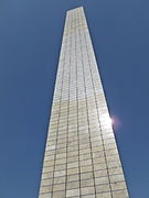
The Angel of Independence – a tall column with a gilded statue of a Winged Victory (that bears resemblance with an angel, therefore its common name) on its top and many marble statues on its base depicting the heroes of the Mexican War of Independence, built to commemorate the centennial of Mexico's independence in 1910. The base contains the tombs of several key figures in Mexico's war of independence.
Near the central section of Reforma, across from the Alameda, is the Monumento a la Revolución ("Monument to the Revolution"). This is an enormous dome supported by four arches. It was originally planned, by Porfirio Díaz, to be a part of a new parliament building, but it never was completed because of the start of the Mexican Revolution. After Díaz's overthrow it became a monument to the revolution that deposed him. The remains of Francisco I. Madero and several other heroes of the Mexican Revolution are buried here.
Points of interest from west to east
| Neighborhood(s) | Point(s) of interest |
| Mexican Federal Highway 15D, Paseo de la Reforma begins | |
| Lomas de Chapultepec | Embassies of Peru, Ukraine, UAE, Israel, Finland, Iraq, Bulgaria |
| Anillo Periférico, Fuente de Petróleos monument to Mexican oil expropriation | |
| Polanco | Lebanon Garden, Intercontinental, Hyatt Regency hotels), Winston Churchill Garden
|
Metro Auditorio
| |
| Chapultepec | Chapultepec Zoo, National Museum of Anthropology, Museo Rufino Tamayo, Chapultepec Castle, Mexico-Azerbaijan Friendship Park, Museo de Arte Moderno |
| crosses Circuito Interior inner ring highway | |
| Cuauhtémoc/Juárez | Main entrance to Torre BBVA Bancomer, Mexican Social Security Institute (IMSS), Torre Reforma, Former Aeroméxico Headquarters Building, The St. Regis Mexico City
|
| Diana the Huntress Fountain ("La Diana") roundabout | |
| Cuauhtémoc/Juárez | Torre Diana, Embassy of Colombia, HSBC Tower, Torre New York Life |
| Angel of Independence ("El Ángel") roundabout | |
| Cuauhtémoc/Juárez | Sheraton María Isabel hotel, Embassy of the United States, Torre Reforma Latino, Marriott hotel, Mexican Stock Exchange |
| Intersection with Río Rhin/ Niza, Glorieta de la Palma ("Palm Tree", or "La Palma") roundabout | |
| Cuauhtémoc/Juárez | Torre MAPFRE, Reforma 222 |
| Intersection with Avenida de los Insurgentes, Monument to Cuauhtémoc | |
| Tabacalera/Juárez | Monument to Christopher Columbus, Hotel Fiesta Americana Reforma, National Lottery building
|
| Intersection with Avenidas Juárez and Bucareli, El Caballito sculpture by Sebastián, view west to the Monumento a la Revolución | |
| Guerrero/Centro Histórico | Torre Caballito ( Metro Garibaldi/Lagunilla, Monument to José de San Martín
|
| Intersection with Eje 2 Norte, becomes Calzada de Guadalupe/ Calzada de los Misterios |
Gallery
-
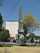 Obelisk to Simón Bolívar
 -
 Reforma and the Angel of Independence as seen from the Torre Mayor
 -
 Church of San Hipólito section
 -
 Straight line eight lanes end near castle
 -
 Bronze vases are placed among the monuments
 -
 Removing the original cactus-themed lawn
 -
 Main entrance of theMuseo Nacional de Antropología(National Anthropology Museum)
 -
-
 Torre St. Regis and the Torre Mayor, as seen from the base of The Angel of Independence
 -

-
-

-

-

-
 Torre del Caballito, named after El Caballito by Sebastián.
 -
 Base of the Monument to Cuauhtémoc
 -
 Plaza Residence
 -
 Monument to José de San Martín
 -
 Monument to Kemal Atatürk, the founding father of the Republic of Turkey


_-_104.jpg)


.jpg)


See also
- Avenida Presidente Masaryk, an upscale shopping district in Polanco, Miguel Hidalgo borough, Mexico City
- Paulista Avenue, a comparable Latin American avenue in São Paulo, Brazil
- The Paseo (Kansas City, Missouri), a 19-mile avenue modeled after Paseo de la Reforma
References
- ^ "Excélsior en la Historia: La metamorfosis de Paseo de la Reforma". Excélsior. 31 July 2013. Retrieved 10 April 2015.
- ISBN 968856799X.
- ^ Claudia Agostoni, Monuments of Progress: Modernization and Public Health in Mexico City, 1876-1910. University of Calgary Press 2003, pp. 79-80.
- ^ a b c d e * Andrés Manuel López Obrador, Manuel Menchaca Mier. (2005). Nuevo Rostro De La Ciudad, Paseo De La Reforma - Centro Histórico. México: Gobierno del Distrito Federal. pp. 50–79. 968-5740-05-4.
- ^ a b c d e "Bienvenid@s al Portal de la Secretaría de Transportes y Vialidad del Gobierno del Distrito Federal". www.setravi.df.gob.mx. Archived from the original on 10 January 2014. Retrieved 15 January 2022.
- ^ Agostoni, Monuments of Progress p. 80
- ^ Justino Fernández, El arte del siglo XIX en México Mexico: Imprenta Universitaria 1967, p. 167 quoted in Agostoni, Monuments of Progress p. 94
- ^ Agostoni, Monuments of Progress, pp. 95-96.
- ^ "Abre sus puertas Reforma 222", El Universal, November 2007
- ^ "Así fue el día 1 de locura de Shake Shack en México". Expansión (in Spanish). 2019-06-28. Retrieved 2019-07-25.
- ^ (in Spanish) El Paseo Dominical Muévete en Bici Mexico City government
- ^ "Paseo Dominical Muévete en Bici CDMX". Mexico City government.
- ^ Agostoni, Monuments of Progress, p. 81