
Pekela
Pekela | |
|---|---|
Municipality | |
_04.jpg) Bridge in Oude Pekela | |
|
UTC+2 (CEST) | |
| Postcode | 9662–9669 |
| Area code | 0597 |
| Website | www |
Pekela (Dutch pronunciation: [ˈpeːkəlaː] ⓘ) is a municipality in the province of Groningen in the Netherlands. It was created in 1990 when Oude Pekela and Nieuwe Pekela were merged.
History
The municipality of Pekela was created when the municipalities of Oude Pekela and Nieuwe Pekela were merged in 1990.[5]
Geography

Pekela is located at 53°6′N 7°0′E / 53.100°N 7.000°E in the southeast of the province of Groningen in the northeast of the Netherlands. It is bordered by the municipalities of:
- Oldambt (in the north)
- Bellingwedde (east)
- Stadskanaal (south)
- Veendam (west)
- Menterwolde (northwest).
The river
The municipality has a total area of 50.20 km2 (19.38 sq mi), of which 49.04 km2 (18.93 sq mi) is land and 1.16 km2 (0.45 sq mi) is water.[2]
Governance
Mayor ( of Pekela consists of 15 seats, which are divided as follows:
| Municipality seats | |||||||||||||||
|---|---|---|---|---|---|---|---|---|---|---|---|---|---|---|---|
| Party | 1998 | 2002 | 2006 | 2010 | 2014 | ||||||||||
PvdA |
6 | 6 | 7 | 3 | 2 | ||||||||||
| GroenLinks | 4 | 3 | 1 | 2 | 1 | ||||||||||
CDA |
2 | 3 | 2 | 1 | 2 | ||||||||||
VVD |
2 | 2 | 1 | 2 | 1 | ||||||||||
SP |
- | - | 3 | 3 | 4 | ||||||||||
ChristenUnie |
1 | 1 | 1 | - | 1 | ||||||||||
| Samen Voor Pekela | - | - | - | 4 | 3 | ||||||||||
| VCP | - | - | - | - | 1 | ||||||||||
| Total | 15 | 15 | 15 | 15 | 15 | ||||||||||
Demographics
In 2021, the municipality had a total population of 12,176 and a population density of 248/km2 (640/sq mi).[4]
Notable people
- Jan de Boer (1859 in Nieuwe Pekela – 1941) a Dutch gymnast who competed in the 1908 Summer Olympics[6]
- Fré Meis (1921–1992), communist politician[7]
- Janneke Snijder-Hazelhoff (born 1952 in Nieuwe Pekela) a Dutch farmer and politician[8]
- Gerard Wiekens (born 1973 in Oude Pekela) a Dutch former footballer with 518 club caps who played for SC Veendam and Manchester City F.C.[9]
Gallery
-
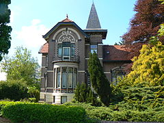 Villa Elsa, Clockstraat, Oude Pekela
 -
 Art project "Geveltjes viadukt" in Nieuwe Pekela
 -
 Het Dokhuis, a retirement home in Oude Pekela
 -
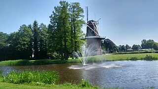 Pekelder Windmill "De Onrust" in Oude Pekela


_02.jpg)
.jpg)
References
- ^ a b "Burgemeester" [Mayor] (in Dutch). Gemeente Pekela. Archived from the original on 21 February 2014. Retrieved 3 February 2014.
- ^ a b "Kerncijfers wijken en buurten 2020" [Key figures for neighbourhoods 2020]. StatLine (in Dutch). CBS. 24 July 2020. Retrieved 19 September 2020.
- ^ "Postcodetool for 9665JD". Actueel Hoogtebestand Nederland (in Dutch). Het Waterschapshuis. Retrieved 3 February 2014.
- ^ a b "Bevolkingsontwikkeling; regio per maand" [Population growth; regions per month]. CBS Statline (in Dutch). CBS. 1 January 2021. Retrieved 2 January 2022.
- ^ Ad van der Meer and Onno Boonstra, Repertorium van Nederlandse gemeenten, KNAW, 2011.
- ^ "Jan de Boer". Olympedia (in Dutch). Retrieved 25 February 2022.
- ^ Gerrit Voerman (2013). "Meis, Frederik (1921-1992)". Biographical Dictionary of the Netherlands (in Dutch). Retrieved 25 February 2022.
- ^ "J.F. (Janneke) Snijder-Hazelhoff". Dutch Parliament (in Dutch). Retrieved 22 February 2022.
- ^ "Gerard Wiekens". World Football. Retrieved 25 February 2022.
External links
Places adjacent to Pekela | |
|---|---|
Municipalities of Groningen | ||
|---|---|---|
 | ||
| ||