
Petrus Plancius
Petrus Plancius | |
|---|---|
 Petrus Plancius by J. Buys/Rein. Vinkoeles (1791) | |
| Born | Pieter Platevoet 1552 Dranouter |
| Died | 15 May 1622 (aged 69–70) |
| Nationality | Flemish |
| Known for | One of the notable figures in the Golden Age of Netherlandish cartography |
| Scientific career | |
| Fields | Astronomy, cartography, theology |
| Institutions | Dutch Reformed Church |
Petrus Plancius (Dutch:
Plancius fled from
Cartography

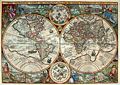
In 1592 Plancius published his best known world map, titled "Nova et exacta Terrarum Orbis Tabula geographica ac hydrographica". Only one remaining copy is known to exist, preserved at the Colegio del Corpus Christi in Valencia, Spain. This copy is not easily accessible to visitors.[1] Plancius also published journals and navigational guides and developed a new method for determining longitude. He also promoted the Mercator projection for navigational maps.
Plancius was one of the founders of the Dutch East India Company, for which he drew over 100 maps.
Plancius was closely acquainted with Henry Hudson, an explorer of the New World.
Plancius prepared the map, Exacta & accurata delinatio… regionibus China, Cauchinchina, Camboja, sive Champa, Syao, Malacca, Arracan & Pegu, published in
Uranography
In 1589 Plancius collaborated with the Amsterdam cartographer Jacob van Langren on a 32.5-cm celestial globe, which, using the sparse information available about southern celestial features, depicted Crux (the southern cross), Triangulum Australe (the southern triangle), and the Magellanic Clouds (Nubecula Major and Minor).
In 1595 Plancius trained
These constellations, together with the constellation Columba illustrated by Plancius on his large wall map of the world of 1592, were then incorporated in 1603 by Johann Bayer in his sky atlas, the Uranometria.
In 1612 (or 1613) Plancius introduced the following eight constellations on a 26.5-cm celestial globe published in Amsterdam by
The minor planet 10648 Plancius commemorates his contributions in celestial and terrestrial cartography.
Maps
-
 Orbis Terrarum 1590
 -
 Orbis Terrarum 1594
 -
 Ceilan, 1595
 -
 Nova Francia .. Terra Nova 1592
 -
 Insulae Moluccae 1592


.jpg)


See also
- First Dutch Expedition to Indonesia
References
- ISBN 978-1-85368-271-1.
- ^ Leo Bagrow, History of Cartography, revised and enlarged by R. A. Skelton, London, Watts, 1964, p.265. Exacta & accurata delinatio cum orarum maritimarum tum etiam locorum terrestrium quæ in regionibus China, Cauchinchina, Camboja, sive Champa, Syao, Malacca, Arracan & Pegu ; Cornelis Koeman, Jan Huygen Van Linschoten, Coimbra, Universidade de Coimbra Biblioteca Geral 1, 1984, Centro de Estudos de Historia e Cartografia, Vol.153, pp.39-41. Also in Revista da Universidade de Coimbra, vol.32, 1985, pp.27-47.
- ^ "On Frederick de Houtman's catalogue of southern stars, and the origin of the southern constellations", by E. B. Knobel, 1917, the catalogue starting at page 421
- ^ a b "Star Tales ― Scouting the southern sky" by Ian Ridpath
- .
- ^ a b c Le costellazioni di Petrus Plancius, on Atlas Coelestis by Felice Stoppa
- ^ Astronomical naming conventions#Names and boundaries of constellations
External links
| International | |
|---|---|
| National | |
| Artists | |
| People | |
| Other | |