
Picture Butte
Picture Butte | |
|---|---|
Town | |
| Town of Picture Butte | |
| Nickname: Livestock Feeding Capital of Canada | |
T0K 1V0 | |
| Highways | Highway 25 Highway 519 |
| Waterway | Oldman River |
| Website | Official website |
Picture Butte is a town in southern Alberta, Canada. It is located 27 km (17 mi) north of the city of Lethbridge. It claims the title of "Livestock Feeding Capital of Canada."
Name
In 2010, Ernest and Austin Mardon stated that "the name is descriptive, being a translation of the Blackfoot 'the beautiful hill.'"[6]
History
Picture Butte received its name from a prominence southeast of town. By 1947, however, the prominence's soil had been reworked and used for street improvements, highway construction and a dyke on the shore of the Picture Butte Lake Reservoir. The prominence no longer exists.
Homesteading in the area began in the early 20th century. The building of the Lethbridge Northern Irrigation System in 1923 and the CPR rail line in 1925 stimulated an influx of settlers. The first post office opened in 1925.[7]
In 1943, Picture Butte became a village, and it attained town status in 1961 with a population of 978.
The Canadian Sugar Factory closed in 1978 and resulted in the loss of tax revenues and employment opportunities to the town. Industrial activity consists of small service, warehousing and wholesaling industries.
The town annexed approximately 165 acres (0.67 km2) in 1991, significantly changing the town's boundary since the general municipal plan of 1980.[8]
A number of farms and properties in the Picture Butte area have changed and adapted over time; for example, in 2016, the Natural Resources Conservation Board approved Scholten Farms' request to convert swine feeders to cattle feeders.[9]
Demographics
In the 2021 Census of Population conducted by Statistics Canada, the Town of Picture Butte had a population of 1,930 living in 689 of its 729 total private dwellings, a change of 6.6% from its 2016 population of 1,810. With a land area of 3.02 km2 (1.17 sq mi), it had a population density of 639.1/km2 (1,655.2/sq mi) in 2021.[3]
In the
Attractions
As of 2023, Picture Butte has an art gallery, three schools, three churches, a sports complex, a community league, a museum and a historical village.[11]
Governance

List of mayors of Picture Butte
- John Maurice Gibbons
- Heber Jones
- Harry Watson
- Sydney P. Johnson
- Wilfrid Hague
- Victor Edward (Ted) Crapnell
- Morgan W. Heninger
- Rick Casson
- Bert Foord
- Alex Chronik
- Elton Anderson
- Jon Stevens
- Terry Kerkhoff
- Wendy Jones
- Cathy Moore
Current municipal council
The current Picture Butte town council was elected on October 18, 2021 in the 2021 Alberta municipal elections.[12] As of 2023, the Mayor of Cathy Moore and councilors include Henry deKok, Teresa Feist, Cynthia Papworth and Scott Thomson.[13]
Gallery
-
 Baseball game at Picture Butte School
 -
 Picture Butte grain elevator
 -
 Chicken farm in Picture Butte
 -
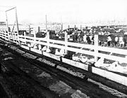 Cattle feedlot in picture butte
.jpg)
.jpg)
.jpg)
.jpg)
Notable people
- Alex Brown Johnston, politician
- Rick Casson, politician
- Shane Mazutinec, WHL hockey player
See also
References
- Alberta Municipal Affairs. October 7, 2016. p. 477. Retrieved October 13, 2016.
- Alberta Municipal Affairs. May 9, 2019. Retrieved October 1, 2021.
- ^ a b c "Population and dwelling counts: Canada, provinces and territories, and census subdivisions (municipalities)". Statistics Canada. February 9, 2022. Retrieved February 9, 2022.
- ^ "Alberta Private Sewage Systems 2009 Standard of Practice Handbook: Appendix A.3 Alberta Design Data (A.3.A. Alberta Climate Design Data by Town)" (PDF) (PDF). Safety Codes Council. January 2012. pp. 212–215 (PDF pages 226–229). Retrieved October 9, 2013.
- ^ "Population and dwelling counts: Canada and population centres". Statistics Canada. February 9, 2022. Retrieved February 13, 2022.
- ISBN 9781897472170.
- ^ Coyote Flats Historical Society (1967). Coyote Flats : historical review, 1905-1965. Volume 1. Lethbridge: Southern Printing. p. 275.
- ^ "Town of Picture Butte Municipal Development Plan" (PDF). Oldman River Regional Services Commission. March 2004. Archived from the original (PDF) on 2007-09-28. Retrieved 2007-08-27.
- ^ "Confined Feeding Operations". The Sunny South News. Coaldale. December 13, 2016. p. 8.
- ^ "Population and dwelling counts, for Canada, provinces and territories, and census subdivisions (municipalities), 2016 and 2011 censuses – 100% data (Alberta)". Statistics Canada. February 8, 2017. Retrieved February 8, 2017.
- ^ Buzz (2013-05-23). "ROAD TRIP: What Is There To Do In Picture Butte?". The Blog According To Buzz. Retrieved 2023-10-14.
- ^ "Council Members". Town of Picture Butte. Retrieved March 9, 2023.
- ^ "Council Members". Town of Picture Butte. Retrieved March 9, 2023.
External links
Places adjacent to Picture Butte | |
|---|---|