
Poggio Catino
Poggio Catino | |
|---|---|
| Comune di Poggio Catino | |
 Panoramic view | |
.svg) | |
Location of Poggio Catino  | |
UTC+2 (CEST) | |
| Postal code | 02040 |
| Dialing code | 0765 |
| Patron saint | St. Sylvester and St. Roch |
| Saint day | 31 December and 16 August |
| Website | Official website |
Poggio Catino is a comune (municipality) in the Province of Rieti in the Italian region of Latium, located about 45 kilometres (28 mi) northeast of Rome and about 20 kilometres (12 mi) southwest of Rieti. As of 31 December 2011, it had a population of 1,335 and an area of 15.0 square kilometres (5.8 sq mi).[2]
History
The village was created at the end of the 11th century, above the Moricone hill, to find a larger building space than that of the nearby village of Catino, founded in the 7th century, and nowadays a hamlet of it. The toponym itself describes the
Geography
Poggio Catino is a hilltown part of the historic region of Sabina. The municipality borders with Cantalupo in Sabina, Forano, Poggio Mirteto, Roccantica and Salisano.[4]
Its only hamlet (
Demographics

Gallery
-
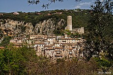 Panoramic view of Catino with the Longobard fortress in background
 -
 The Longobard fortress of Catino

_(5487186492).jpg)
Personalities
- Gregory of Catino (1060–1130), Christian monk and historian
References
- ^ "Superficie di Comuni Province e Regioni italiane al 9 ottobre 2011". Italian National Institute of Statistics. Retrieved 16 March 2019.
- ^ Istat2011
- ^ (in Italian) Historical info about Poggio Catino on sabina.it
- ^ 41931 Poggio Catino on OpenStreetMap
- ^ (in Italian) Catino on italia.indettaglio.it
External links
- (in Italian) Poggio Catino official website
- (in Italian) Poggio Catino page on Sabina website