
Poobong Tea Garden
Poobong Tea Garden
Chota Poobong | |
|---|---|
Village | |
UTC+5:30 (IST) | |
| PIN | 734102 |
| Telephone code | 0091 354 |
| Vehicle registration | WB- |
| Coastline | 0 kilometres (0 mi) |
| Nearest city | Ghoom |
| Sex ratio | 1;1 ♂/♀ |
| Literacy | 40% |
| Avg. summer temperature | 25 °C (77 °F) |
| Avg. winter temperature | 2 °C (36 °F) |
| Website | darjeeling |
Poobong Tea Garden (also spelled Pubong) is a village in the
Etymology
Poobong means 'a valley behind the clouds'. [1]
History
Poobong Tea Estate was established in 1913.[2]
Geography


5miles
CT: census town, R: rural/ urban centre, NP: national park/ wildlife sanctuary, TE: tea estate
Abbreviations used in names – TG for Tea Garden (town/village), TE for Tea Estate
Owing to space constraints in the small map, the actual locations in a larger map may vary slightly
Area overview
The map alongside shows a portion of the southern portion of the Darjeeling Himalayan hill region in the Darjeeling district. In the Darjeeling Sadar subdivision 61.00% of the total population lives in the rural areas and 39.00% of the population lives in the urban areas. In the Mirik subdivision 80.11% of the total population lives in rural areas and 19.89% lives in urban areas.[3][4] There are 78 tea gardens/ estates (the figure varies slightly according to different sources), in the district, producing and largely exporting Darjeeling tea. It engages a large proportion of the population directly/ indirectly.[5] Some tea gardens were identified in the 2011 census as census towns or villages.[6] Such places are marked in the map as CT (census town) or R (rural/ urban centre). Specific tea estate pages are marked TE.
Note: The map alongside presents some of the notable locations in the subdivision. All places marked in the map are linked in the larger full screen map.
Location
This section needs additional citations for verification. (March 2020) |
Poobong, situated between
From the main road it is around 3.5 km rough road down towards the village. The main sources of income of this place was/is working in the Tea Garden but some are engaged in agriculture and some go to work in different parts of India and abroad.
Poobong has two divisions: Tea estate and Busty. There are 4 primary schools, Chettri Goan Primary School, Poobong Kaman Primary School, Alubari Primary School and Poobong Fatak Primary School; one junior high school is in school Dara. For higher education one has to go to Ghoom, Sukhia, Darjeeling etc.
Demographics
According to the
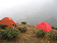
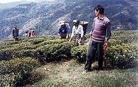
Gallery
-
 Tea Gardan
 -
 Local House
 -


References
- ^ a b "Poobong Tea Estate". Darjeeling Tea Boutique. Retrieved 6 March 2020.
- ^ "Poobong Tea Estate". Tea Box. Retrieved 6 March 2020.
- ^ "Darjeeling". District Profile - General Information. District administration. Retrieved 21 March 2020.
- ^ "District Statistical Handbook 2013 Darjeeling". Tables 2.2, 2.4b. Department of Planning and Statistics, Government of West Bengal. Archived from the original on 21 January 2019. Retrieved 21 March 2020.
- ^ "Darjeeling Tea". District administration. Retrieved 21 March 2020.
- ^ "2011 Census – Primary Census Abstract Data Tables". West Bengal – District-wise. Registrar General and Census Commissioner, India. Retrieved 21 March 2020.
- ^ "2011 Census – Primary Census Abstract Data Tables". West Bengal – District-wise. Registrar General and Census Commissioner, India. Retrieved 3 March 2020.
External links
This article about a location in the Darjeeling district of West Bengal is a stub. You can help Wikipedia by expanding it. |