
Portage Lake Lift Bridge
Portage Lake Lift Bridge | |
|---|---|
Portage Lake | |
| Locale | Hancock and Houghton, Michigan |
| Official name | Houghton–Hancock Bridge |
| Maintained by | MDOT |
| ID number | 3380 |
| Characteristics | |
| Design | Vertical-lift bridge |
| Total length | 1,310 feet (400 m) |
| Width | both decks: 4 lanes with no shoulders lower deck: single-track railroad was abandoned 1982. |
| Height | 180 ft (55 m)[1] |
| Longest span | 269 ft (82 m) |
| Clearance below | 4 ft (1.2 m) fully lowered 32–36 ft (9.8–11.0 m) raised to intermediate position About 100 ft (30 m) fully raised) |
| History | |
| Opened | 1959 |
| Statistics | |
| Daily traffic | >20,000[2] |
| Location | |
 | |
The Portage Lake Lift Bridge (officially the Houghton–Hancock Bridge[3]) connects the cities of Hancock and Houghton, in the US state of Michigan. It crosses Portage Lake, a portion of the waterway which cuts across the Keweenaw Peninsula with a canal linking the final several miles to Lake Superior to the northwest. US Highway 41 (US 41) and M-26 are both routed across the bridge. It is the only land-based link between the north (so-called Copper Island) and south sections of the Keweenaw peninsula.[4] In June 2022, it was dedicated as a National Historic Civil Engineering Landmark.[5]
This
Hancock and Houghton hold an annual celebration called Bridgefest to commemorate the opening of the bridge which united their two communities.[8]
History
The original bridge on the same site was a wooden

The original 1959 design by Hazelet and Erdal of Chicago of the bridge's liftspan had roadways constructed on both levels with rails embedded in the road surface on the lower deck. This allowed the span to be partially raised to allow small and medium boat traffic to pass underneath without disrupting vehicular traffic. From this middle position, the span would then only need to be raised for large ships or lowered to allow trains to cross. With the end of rail service in 1982, the lowest position is no longer needed to allow trains to pass so the bridge is not lowered below the middle position during the summer boating season except for periods of maintenance or repair. In the winter after the lake freezes, the bridge is placed in the lowest position to allow the lower deck to be used by snowmobile traffic.[3]
Gallery
-
 Frozen Keweenaw Waterway at night
 -
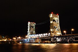 The Portage Lake Lift Bridge at night
 -
 Looking north while crossing bridge
 -
 Elevated to let boats pass underneath
 -
 The Copper Country Limited crossing the Portage Lake Lift Bridge in 1967
 -
 View from Houghton
 -
 View showing lower deck looking toward Hancock

.JPG)


.jpg)


See also
References
- Archive.org.
- OCLC 9940134. Retrieved August 5, 2010.
- ^ a b Michigan Department of Transportation (May 10, 2002). "US 41 – Portage Lake". Michigan's Historic Bridges. Michigan Department of Transportation. Retrieved August 4, 2010.
- ^ "Virtual Adventures". Keweenaw Convention and Visitors Bureau. Archived from the original on July 21, 2011. Retrieved August 4, 2010.
- ^ "Portage Lake Lift Bridge connecting Houghton, Hancock recognized as historic landmark". FOX 2 Detroit. June 21, 2022. Retrieved June 26, 2022.
- ^ Federal Highway Administration. "Copper Country Trail: Portage Lake Lift Bridge, MI". America's Byways. Federal Highway Administration. Archived from the original on October 9, 2007. Retrieved August 4, 2010.
- ^ Forgrave, Mike; Forgrave, Tricia. "Portage Lift Bridge". Keweenaw Free Guide. Retrieved August 4, 2010.
- ^ "Welcome to Bridgefest!". Bridgefest. Retrieved August 4, 2010.
- ^ Smith, D (1986). "Houghton–Hancock Crossing". Michigan Tech Archives & Copper Country Historical Collections. pp. 1–13.
- ^ Hyde (1993), p. 152.
External links
- Keweenaw Crossing: Michigan's Elevator Bridge - Michigan Department of Transportation video
- Michigan Tech Bridge Cam
- Portage Lake BridgeCam
- Bridgefest Website
- City of Hancock Bridge History Page
- King Bridge Company older bridge history page
- Copper Range historical society information
- Michigan Department of Transportation Historic Bridges US41 Portage Lake page