
Pre-Noachian
| Pre-Noachian | |
|---|---|
lowlands representing the Pre-Noachian landscape, alongside higher terrain indicative of the Noachian era. | |
| Usage information | |
| Celestial body | Mars |
| Time scale(s) used | Martian Geologic Timescale |
The Pre-Noachian is a
The Pre-Noachian period created
During the Pre-Noachian period,
During this time, Mars had a distinct magnetic field because its core was active. As magma cooled in the planet's lower layers, it formed metals necessary to make the magnetic field.[3]
Description and name origin
The Pre-Noachian System and Period is named after
Pre-Noachian chronology and stratigraphy

Martian time periods are based on
System vs. Period
| Segments of rock (strata) in chronostratigraphy | Periods of time in geochronology | Notes (Mars) |
|---|---|---|
| Eonothem | Eon |
not used for Mars |
| Erathem | Era |
not used for Mars |
| System | Period |
3 total; 108 to 109 years in length |
| Series | Epoch |
8 total; 107 to 108 years in length |
| Stage | Age |
not used for Mars |
| Chronozone | Chron |
smaller than an age/stage; not used by the ICS timescale |
System and Period are not interchangeable terms in formal stratigraphic nomenclature, although they are frequently confused in popular literature. A system is an idealized stratigraphic
At any location, rock sections in a given system are apt to contain gaps (
Boundaries and subdivisions
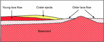
The lower boundary of the Pre-Noachian period on Mars is characterized by the emergence of significant geological activity and the initial shaping of the planet's surface during its early history. This boundary is defined by the presence of ancient cratered terrains, volcanic constructs, and impact ejecta deposits dating back to the earliest stages of Martian geological development. While the precise location of this boundary may vary depending on geological context and criteria used for its definition, it marks the beginning of Mars’ geological history as understood by scientists.
In the Pre-Noachian period, the eastern region of Mars featured ridged plains overlaying early to mid-Noachian aged cratered plateau materials. This period marked a significant phase in Mars’ geological history, preceding the Noachian era characterized by its own distinct geological features and processes.
The Pre-Noachian System is subdivided into two chronostratigraphic
Stratigraphic terms are often confusing to geologists and non-geologists alike. One way to sort through the difficulty is by the following example: You can easily go to
The Earth-based scheme of formal stratigraphic nomenclature has been successfully applied to Mars for several decades now but has numerous flaws. The scheme will no doubt become refined or replaced as more and better data become available.[15] (See mineralogical timeline below as example of alternative.) Obtaining radiometric ages on samples from identified surface units is clearly necessary for a more complete understanding of Martian history and chronology.[16]
Mars during the Pre-Noachian Period

During the Pre-Noachian period, Mars experienced significant geological and environmental dynamics. Intense volcanic activity sculpted the planet's surface through widespread eruptions, while impact cratering events left behind numerous craters across the
References
- ^ a b c d e "The ages of Mars". Mars Express - European Space Agency (ESA). Retrieved 25 March 2024.
- .
- .
- ^ Amos, Jonathan (10 September 2012). "Clays in Pacific Lavas Challenge Wet Early Mars Idea". BBC News.
- ^ See Mutch, T.A. (1970). Geology of the Moon: A Stratigraphic View; Princeton University Press: Princeton, NJ, 324 pp. and Wilhelms, D.E. (1987). The Geologic History of the Moon, USGS Professional Paper 1348; http://ser.sese.asu.edu/GHM/ for reviews of this topic.
- ^ Wilhelms, D.E. (1990). Geologic Mapping in Planetary Mapping, R. Greeley, R.M. Batson, Eds.; Cambridge University Press: Cambridge UK, p. 214.
- ^ Tanaka, K.L.; Scott, D.H.; Greeley, R. (1992). Global Stratigraphy in Mars, H.H. Kieffer et al., Eds.; University of Arizona Press: Tucson, AZ, pp. 345–382.
- ^ .
- ^ International Commission on Stratigraphy. "International Stratigraphic Chart" (PDF). Retrieved 2009-09-25.
- ^ ISBN 0-13-390047-9.
- )
- ^ Hartmann, W.K.; Neukum, G. (2001). Cratering Chronology and Evolution of Mars. In Chronology and Evolution of Mars, Kallenbach, R. et al. Eds., Space Science Reviews, 96: 105–164.
- ^ .
- PMID 32332708. Retrieved 2024-03-26.
- ^ Tanaka, K.L. (2001). The Stratigraphy of Mars: What We Know, Don't Know, and Need to Do. 32nd Lunar and Planetary Science Conference, Abstract #1695. http://www.lpi.usra.edu/meetings/lpsc2001/pdf/1695.pdf.
- ^ Carr, 2006, p. 41.