
President's Park
President's Park | |
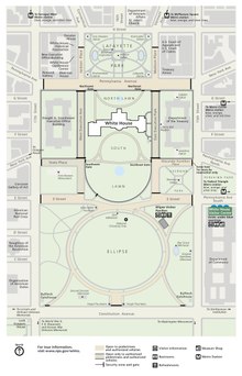
 President's Park in Washington, D.C., including (left to right in center): The Ellipse, the White House, and Lafayette Square | |
   | |
| Location | Washington, D.C., U.S. |
|---|---|
| Coordinates | 38°53′46″N 77°2′12″W / 38.89611°N 77.03667°W |
| Area | 77.48 acres (313,536 m²) |
| Built | 1791 |
| Architect | L'Enfant, Pierre C.; Downing, A.J. |
| Visitation | 714,224 (2022)[2] |
| Website | President's Park (White House) |
| NRHP reference No. | 80000347[1] |
| Added to NRHP | May 6, 1980 |
President's Park, located in Downtown
President's Park was the original name of Lafayette Square.President's Park is administered by the National Park Service.[4]
The park is officially referred to as President's Park or The White House and President's Park.[5]
White House and adjacent buildings
In 1790, under the Residence Act, Philadelphia was designated as the nation's temporary capital while the permanent capital was constructed in Washington, D.C. Contests were held to solicit designs for both the United States Capitol and what was then called the President's House. James Hoban's design was selected, and he supervised the construction.
The new national capital in Washington, D.C., was finalized and opened in 1800.
The
To the west of the White House, across from the West Wing is the Eisenhower Executive Office Building, formerly the Department of State, War, and Navy, and to the east is the Treasury Building.
Lafayette Square
Lafayette Square is a 6.97 acre (28,191 m2) public park located directly north of the White House on
Lafayette Square has been used as a racetrack, a graveyard, a zoo, a slave market, an encampment for soldiers during the War of 1812, and many political protests and celebrations. Andrew Jackson Downing landscaped Lafayette Square in 1851 in the picturesque style.
The Ellipse

President's Park South, commonly called The Ellipse, is a 52 acres (21 ha) park located just south of the White House fence. The entire park is open to the public, and features various monuments within walking distance, including the Washington Monument, the Lincoln Memorial, the Jefferson Memorial, and others.
The park was conceived in 1791, the first plan for the park was drawn up by Pierre (Peter) Charles L'Enfant. During the Civil War between 1861 and 1865, the grounds of the Ellipse and the not yet complete Washington Monument were used as corrals for horses, mules, and cattle, and as campsites for Union Army troops. The Army Corps of Engineers began landscaping work on the Ellipse in 1867 and worked on it through the late 1880s.
White House Visitor Center
The White House Visitor Center is located in the north end of the Herbert C. Hoover Building, which also houses the Department of Commerce, located off The Ellipse between 14th and 15th Streets on Pennsylvania Avenue NW,
Since the September 11 attacks, the visitor center no longer serves as a starting point for those going on a reserved tour of the White House. The various exhibits provide an alternative visitor experience for those not able to go on a tour. The themes of the six permanent exhibits are first families, symbols and images, White House architecture, White House interiors, the working White House, and ceremonies and celebrations. Other exhibits change throughout the year.
References
- ^ "National Register Information System". National Register of Historic Places. National Park Service. April 15, 2008.
- ^ "NPS Annual Recreation Visits Report". National Park Service. Retrieved October 16, 2023.
- ^ "Reservation List: The Parks of the National Park System, Washington, DC" (PDF). www.nps.gov. National Park Service; Land Resources Program Center; National Capital Region. Archived (PDF) from the original on 22 February 2017. Retrieved 25 November 2017.
- ^ "President's Park (White House) – U.S. National Park Service". Nps.gov. Archived from the original on 2021-03-18. Retrieved 2010-01-26.
- ^ "Foundation Document: The White House and President's Park" (PDF). National Park Service. Archived (PDF) from the original on 24 February 2017. Retrieved 30 November 2017.
Further reading
- Moser, Edward P. The White House's Unruly Neighborhood: Crime, Scandal and Intrigue in the History of Lafayette Square (McFarland, 2020) online review.
- The National Parks: Index 2001–2003. Washington: U.S. Department of the Interior.