
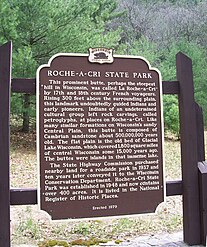
Roche-a-Cri State Park
| Roche-a-Cri State Park | |
|---|---|
IUCN category V (protected landscape/seascape) | |
 | |
  | |
| Location | Adams, Wisconsin, United States |
| Coordinates | 44°0′9″N 89°49′10″W / 44.00250°N 89.81944°W |
| Area | 605 acres (245 ha) |
| Established | 1948 |
| Governing body | Wisconsin Department of Natural Resources |
Roche-a-Cri State Park (from the French for crevice in the rock) is a state park north of Adams and Friendship in central Wisconsin. The park, 605 acres (245 ha) in area, was established in 1948.
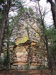
The park features a 300-foot (91 m) rock outcropping with Native American petroglyphs—the Roche-a-Cri Petroglyphs—and a wooden stairway to the top, as well as more than 5 miles (8.0 km) of hiking trails.[1] The petroglyphs are the only publicly accessible rock art site in the state of Wisconsin.[2] In addition to the petroglyphs, other rock art such as a pictograph of a thunderbird and a horned human figure can be found at the park.[3]
Natural history
The striking 300-foot (91 m) bluff is a hard core that remains from a larger sheet of
Buzzards also haunt the top.[4]
-
 Outcropping rock
 -
 Sign
Sign -
 The park from the south


References
- ^ "Roche-a-Cri State Park". WilderNet. Retrieved September 1, 2013.
- ^ Boszhardt, Robert (2016). Hidden Thunder: Rock Art of the Upper Midwest. Wisconsin Historical Society Press. p. 79.
- ^ Boszhardt, Robert (2016). Hidden Thunder: Rock Art of the Upper Midwest. Wisconsin Historical Society Press. p. 82.
- ^ "Roche-A-Cri State Park: Nature". Wisconsin Department of Natural Resources. Retrieved September 1, 2013.
External links
- Roche-A-Cri State Park Wisconsin Department of Natural Resources