Roetgen
Roetgen | |
|---|---|
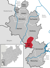
Location of Roetgen within Aachen district  | |
Köln | |
| District | Aachen |
| Subdivisions | 3 |
| Government | |
| • Mayor (2020–25) | Jorma Klauss[1] (SPD) |
| Area | |
| • Total | 39.033 km2 (15.071 sq mi) |
| Elevation | 386 m (1,266 ft) |
| Population (2022-12-31)[2] | |
| • Total | 8,727 |
| • Density | 220/km2 (580/sq mi) |
| Time zone | UTC+01:00 (CET) |
| • Summer (DST) | UTC+02:00 (CEST) |
| Postal codes | 52159 |
| Dialling codes | 02471 |
| Vehicle registration | AC, MON |
| Website | www.roetgen.de |
Roetgen (German pronunciation: [ˈʁøːtçən]]) is a municipality in the district of Aachen, in North Rhine-Westphalia, Germany.
Geography
Roetgen is located approximately 16 km (10 mi) south-east of
The parish of Roetgen includes the villages of Roetgen, Rott and Mulartshütte, which is the oldest part of Roetgen.
To the northwest is the borough of Aachen with its quarters of Kornelimünster and Walheim, to the northeast is the town of Stolberg with its quarters of Venwegen and Zweifall, to the southeast is the Simmerath parish of Lammersdorf. To the west, on the far side of the German-Belgian border lies the town of Eupen and the municipalities of Raeren, whose parish of Petergensfeld borders immediately on Roetgen north of Charliers Mill.
Roetgen is attractive for commuters as it is already part of the Eifel and yet is still close in proximity to Aachen.
History
In World War II, Roetgen was the first German town to fall under American control. American forces arrived in the town on 12 September 1944 at 14:30 hours.[3]
The city was the location of the
On March 13, 2019, Roetgen was hit by a low-end F3 tornado. The tornado caused moderate to severe damage to buildings and trees. Vehicles were also overturned and flipped. 5 people were injured by the tornado.[4][5][6][7][8]
Division of the municipality
Roetgen consists of three districts:
- Roetgen
- Rott
- Mulartshütte
Mulartshütte is the oldest settlement of the three.
Sights
- St. Mary's Chapel (Marienkapelle, 1636–1660) is the surviving part of the first Roman Catholic parish church in Roetgen. It was partially demolished when the Neogothic St. Hubert's Church (1854–1856) was built. It was consecrated to Saint Virgin Mary and John the Baptist.
- In Roetgen's town hall there is a sculpture of a weaver by Hermann Pier (1925–1985); outside on the forecourt is a replica. It has historical as well as artistic value, because this craft was an important part of Roetgen's economic history.
- Charliers Mill (substructure of Weser stream. In the countryside behind the mill, with its pastures, rows of beech rows and ponds runs Stage 1 of the Eifelsteighiking trail.
Gallery
-
St. Hubert's Roman Catholic Church
-
St. Mary's Chapel
-
The Protestant church
References
- ^ Wahlergebnisse in NRW Kommunalwahlen 2020, Land Nordrhein-Westfalen, accessed 19 June 2021.
- Landesbetrieb Information und Technik NRW. Retrieved 20 June 2023.
- ^ New York Times, 14 Sep 1944.
- ^ "Roetgen (Nordrhein-Westfalen), 13.03.2019".
- ^ "13.3.2019 der Roetgener Tornado: Dokumentation vor Ort, Analyse der Zugbahn und Radaranalyse | eifelmomente.de".
- ^ "Tornado in Roetgen: Zerstörte Häuser, Chaos in den Straßen: Windhose in der Eifel". 14 March 2019.
- ^ "Häuser abgedeckt, Laternen umgeknickt: Tornado zieht Schneise der Verwüstung durch Roetgen". 14 March 2019.
- ^ "Langfristige Folgen: Tornadoschäden im Roetgener Wald "schlimm genug"". 26 May 2019.
External links
- Official website
 (in German)


