
Raeren
Raeren | |
|---|---|
 Raeren town hall | |
 Flag  Coat of arms | |
Location of Raeren  | |
 Raeren Location in Belgium
Location of Raeren in the province of Liège Liège | |
| Arrondissement | Verviers |
| Government | |
| • Mayor | Jérôme Franssen |
| • Governing party/ies | Mit Uns - Ecolo |
| Area | |
| • Total | 72.81 km2 (28.11 sq mi) |
| Population (2018-01-01)[1] | |
| • Total | 10,707 |
| • Density | 150/km2 (380/sq mi) |
| Postal codes | 4730–4731 |
| NIS code | 63061 |
| Area codes | 087 |
| Website | www.raeren.be |
Raeren (German pronunciation: First World War, after which it became part of Belgium. It is one of several towns in eastern Belgium which predominantly speak German.
On 1 January 2006, Raeren had a total population of 10,091. The total area is 74.21 km2 which gives a population density of 136 inhabitants per km2. The municipality consists of the following sub-municipalities: Eynatten, Hauset, and Raeren proper.
Secretary-General of the OECD, was raised in Raeren.[2]
Transportation
Its Raeren railway station was the hub and headquarters of the Vennbahn railway.
-
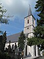 Raeren, church: Sankt Nikolauskirche
 -
 Raeren Castle


See also
- List of protected heritage sites in Raeren
- German-speaking community of Belgium
- Vlattenhaus
References
- ^ "Wettelijke Bevolking per gemeente op 1 januari 2018". Statbel. Retrieved 9 March 2019.
- ^ Kitney, Geoff (2 May 2014). "Mathias Cormann: A tale of two lives". The Age. Retrieved 2 May 2014.
Wikimedia Commons has media related to Raeren.
Places adjacent to Raeren | |
|---|---|
Municipalities in the province of Liège, Wallonia | ||
|---|---|---|
| Huy |  | |
| Liège | ||
| Verviers | ||
| Waremme | ||
| ||
| International | |
|---|---|
| National | |
| Geographic | |
This Liège Province location article is a stub. You can help Wikipedia by expanding it. |