
Rohkunborri National Park
| Rohkunborri National Park | |
|---|---|
| Location | Troms, Norway |
| Nearest city | Setermoen |
| Coordinates | 68°33′54″N 18°51′56″E / 68.56500°N 18.86556°E |
| Area | 571 km2 (220 sq mi) |
| Established | 2011 |
 | |
Rohkunborri National Park (
Bardu Municipality along the border with Sweden, about 30 kilometres (19 mi) southeast of the village of Setermoen and about 50 kilometres (31 mi) northeast of the town of Narvik
.
Rohkunborri borders on the Swedish Vadvetjåkka National Park to the south, and it is located less than 10 kilometres (6.2 mi) south of Øvre Dividal National Park. The park includes parts of the Sørdalen valley (canyon), the large lake Geavdnjajávri, and the mountain Rohkunborri. The large lakes Altevatnet and Leinavatnet both lie just north of the park boundary.[1]
The nature varies from rich boreal deciduous forest on the lower elevations to
Arctic rhododendron (no:Lapprose) is present. The lakes in the eastern part have Arctic char. The mountains on both sides of the canyon reach up to 1,500 metres (4,900 ft) above sea level.[3]
Gallery
-
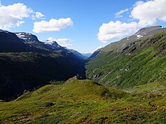 Sørdalen valley (canyon)
 -
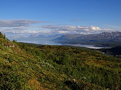 Rohkunborri is located adjacent to Sweden, near the large lake Torneträsk
 -
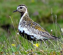 Golden Plover in Rohkunborri


References
- Store norske leksikon(in Norwegian). Oslo: Kunnskapsforlaget. Retrieved 22 August 2011.
- ^ "Rohkunborri nasjonalpark i Troms er opprettet" (in Norwegian). Norwegian Ministry of the Environment. 25 February 2011.
- ^ "Rohkunborri nasjonalpark er opprettet" (PDF) (in Norwegian). Direktoratet for Naturforvaltning.
External links
Wikimedia Commons has media related to Rohkunborri National Park.

This article about a location in Troms is a stub. You can help Wikipedia by expanding it. |
This article related to a protected area in Europe is a stub. You can help Wikipedia by expanding it. |