
Ross Creek Reservoir
| Ross Creek Reservoir | |
|---|---|
ASL | |
| Settlements | Dunedin |
| References | [1] |
The Ross Creek Reservoir is an
The reservoir, dams, and picturesque valve tower have a
The reservoir is located in a heavily wooded valley in the suburb of
Ross Creek Reserve

The reservoir is surrounded by a public reserve which has been allowed to regenerate with native bush. Though not technically covered by the New Zealand Reserves Act, the area is referred to as a reserve and managed and maintained as such by the Dunedin City Council, by virtue of its high scenic and recreational value.[5] This lies between Tanner and Rockside Roads in Glenleith and Cannington Road in Maori Hill. The winding Burma Road runs through the reserve to the north and west of the reservoir. One of Dunedin's most popular golf courses, Balmacewen Golf Course, abuts the reserve's southwest corner. The highest point in the reserve, in its northeastern corner close to Tanner Road, is some 190 metres (620 ft) above sea level.
Numerous popular walking tracks lead to and circle the reservoir, and follow the course of the Ross Creek and its tributary, School Creek. Track counters have recorded as many as 4,000 walkers on the tracks per month, making them some of Dunedin's most well-used bush walks.
Notable features of the reserve — other than the reservoir — include a waterfall which cascades some 20 metres (66 ft) into School Creek. Though these falls appear completely natural, they were created by the diversion of Ross Creek to form the reservoir, and now carry waters from the creek's flood channel. The lower parts of the reserve's tracks close to Glenleith are also notable, as they pass through the narrowest part of the Ross Creek's valley, which rises as canyon walls on both sides of the track and creek.
Gallery
-
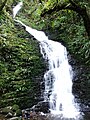 The School Creek Waterfall was created when the waters of Ross Creek were diverted during construction of the reservoir.
 -
 Reservoir valve tower
 -
 Ross Reservoir, Dunedin (1925)
 -
 tRustic bridge at Ross Reservoir, Dunedin (1925)


Notes
- ^ a b Dunedin City Council website
- ^ 2003 conference notes, Geological Society of New Zealand
- ^ "Ross Creek Valve Tower". New Zealand Heritage List/Rārangi Kōrero. Heritage New Zealand. Retrieved 23 March 2009.
- ^ "Ross Creek Earth Dam". New Zealand Heritage List/Rārangi Kōrero. Heritage New Zealand. Retrieved 23 March 2009.
- ^ ISBN 978-0-473-13772-4
References
- Herd, J., and Griffiths, G. J. (1980). Discovering Dunedin. Dunedin: John McIndoe. ISBN 0-86868-030-3.
- McLean, G., and Sheehan, G. (2002) 100 historic places in New Zealand. Auckland: Hodder Moa Beckett. ISBN 1-86958-920-3.