
Route 46 Passaic River Bridge

The Route 46 Passaic River Bridge can refer to a number of bridges that carry U.S. Route 46 (US 46) over the Passaic River in Northern New Jersey. US 46 was originally developed as Route 6 under the direction of Morris Goodkind who was chief engineer of the New Jersey Highway Department (predecessor to the New Jersey Department of Transportation) from 1922 until 1955.
The highway is designated the United Spanish War Veterans Memorial Highway.[1] It crosses the river several times as both wind their way through Bergen, Passaic, Essex, and Morris counties. To the east the highway also crosses the Hackensack River on the Winant Avenue Bridge and the Hudson River (to the state line) on the George Washington Bridge. To the west the highway crosses several of the Passaic's tributaries.[2]
Route 6 (1927–1953) and Route 46 (1953–present)
The expansion of the highway system followed the opening of the George Washington Bridge.[3]
.svg)

In the 1927 New Jersey state highway renumbering Route 6 was assigned to the route across northern New Jersey, using the old Route 5 from Delaware to Netcong, Route 12 from Hackettstown to Paterson, and a generally new alignment parallel to Route 10 from Paterson to the proposed George Washington Bridge. In Paterson, Route 6 was marked along city streets including McBride Avenue, Spruce Street and Market Street.[4][5]
In 1929, Route 6 was redefined to use none of the old road east of Paterson (it had formerly been planned to use Market Street west of roughly where
The Route 6 designation was dropped in favor of US 46 in the 1953 renumbering.[7]
Bridges
Bridge aesthetics and the use of concrete for its moldable qualities characterized 1920-1930s New Jersey State Highway Department bridge design. The NJ 6 bridges use motifs seen on other bridges in the state. The encased steel stringer spans have
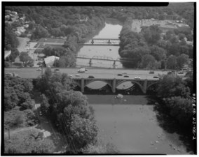
The Passaic River Bridge at Paterson and Passaic River Bridge at Totowa are significant sophisticated examples of an
| Crossing | Dates | Type | Locale/Municipality | Coordinates | NBI | Notes | References |
|---|---|---|---|---|---|---|---|
| Route 46 MP 64.52
|
1955 | culvert | Elmwood Park | 40°53′38″N 74°07′44″W / 40.8938°N 74.1290°W | 0220152 | over branch of the Passaic | [2][13][14] |
| Passaic River Bridge aka Crooks Avenue Bridge MP 63.95 |
c.1937 1995 rebuild |
open spandrel (false concrete arch;true steel girder) |
Paterson - Elmwood Park |
40°53′38″N 74°07′44″W / 40.8938°N 74.1290°W | 1607168 | Cedar Lawn Cemetery site of Weasel Bridge, Cadmus Ford Bridge |
[15][16][17][18][19][2][20][21] |
| Passaic River Bridge MP 57.94 |
1939 1998 rehab |
open spandrel
|
Totowa - Little Falls |
40°53′25″N 74°13′12″W / 40.8903°N 74.2199°W | 1606158 | [2][16][18][20][22] | |
| Route 46 dual bridges MP 55.45 |
c.1927 1951 second bridge |
Wayne - Fairfield Township |
40°53′33″N 74°15′57″W / 40.8925°N 74.2658°W | EB 0722157 WB 0722158 |
[2][18][23][24] | ||
| Route 46 MP 51.85 |
1940 2008 rebuilt |
stringer | Fairfield Township - Pine Brook, Montville |
40°51′45″N 74°19′16″W / 40.86250°N 74.32114°W | 1410159 | Great Piece Meadows | [2][18][25][26] |
| Pine Brook Bridge |
c.1940 1981 reinforce |
stringer | 40°51′31″N 74°19′09″W / 40.8585°N 74.3193°W | 1430153 | originally built as part of Route 6 Great Piece Meadows |
[25][26][27] | |
| Bloomfield Avenue U.S. Route 46 dual bridges
|
1940 1921 |
stringer | Pine Brook, Montville | 40°51′33″N 74°19′39″W / 40.85924°N 74.32758°W | WB-1410158 EB-1431051 |
over a branch of the Passaic | [18][2][27][26][21] |
Gallery
-
 At Paterson
 -
 At Paterson
 -
 At Totowa
 -
 Route 6 originally crossed Lackawanna Avenue just north of Route 46 Totowa bridge
 -
 At Wayne - Fairfield


See also
- List of crossings of the Upper Passaic River
- List of crossings of the Lower Passaic River
- List of crossings of the Hackensack River
- List of fixed crossing of the North River (Hudson River)
- List of bridges documented by the Historic American Engineering Record in New Jersey
References
- ^ "New Jersey Department of Transportation Dedicated Highways and Bridges" (PDF). New Jersey State Library. October 25, 2012. Retrieved November 25, 2016.
- ^ a b c d e f g New Jersey Department of Transportation (July 2014). "US 46 Straight Line Diagram" (PDF). New Jersey Department of Transportation. Retrieved November 21, 2016.
- ^ "Over the New Span" (PDF). The New York Times. October 18, 1931. Retrieved January 30, 2017.
- ^ State of New Jersey. Laws of 1927. Chapter 319.[full citation needed]
- ^ Unknown (n.d.). Sketch Map Showing Approximate Location of New Jersey State Highway Routes as Designated by Chapter 319, Laws of 1927 (Map). Scale not given. n.p.: n.p. Archived from the original on October 1, 2008. Retrieved October 8, 2008.
- ^ a b State of New Jersey. Laws of 1929. Chapter 126.[full citation needed]
- ^ OCLC 1645522. Retrieved November 25, 2016.
- ^ Mid-West Map Co. (1937). Official Road Map of Pennsylvania and New Jersey (Map). Scale not given. n.p.: Mid-West Map Co. Retrieved March 29, 2009.
- H.M. Gousha (1941). Official Road Map of Pennsylvania and New Jersey(Map). Scale not given. n.p.: Mid-West Map Co. Retrieved March 29, 2009.
- ^ United States Geological Survey (1947). Newark, New Jersey Quadrangle (Topographic map). 1:250,000. Reston, VA: United States Geological Survey. Retrieved November 28, 2009 – via University of Texas Libraries.
- ^ a b A. G. Lichtenstein & Associates, Inc. for NJDOT and FHWA (2001). "Historic Bridge Survey (1991–1994)". New Jersey Department of Transportation. Retrieved January 20, 2017.
By the time construction was underway in 1936-1940, State Highway Department engineers were using well-tried highway and bridge engineering designs already in use on such routes as the Route 1 Extension in Hudson County. The survey evaluated 22 bridges constructed as part of the NJ 6 project including 18 encased steel stringers, three open spandrel arches, and one thru girder. The encased steel stringer spans, which carry the highway over or under city streets, other state highways, and railroads, have Moderne-style concrete pilasters and balustrades that lend a sense of coherent design to the route, but are not in and of themselves technologically or architecturally significant. The emphasis on bridge aesthetics and the moldable qualities of concrete was a hallmark of 1920s and 1930s New Jersey State Highway Department bridges, and the NJ 6 bridges mirror motifs seen on bridges in other parts of the state. The bridges that carried NJ 6 over the Passaic River and adjacent highways received special attention from the State Highway Department Bridge Division. The Passaic River crossings were among the most distinguished and elaborate bridges in the state due to the decision of former State Bridge Engineer Morris Goodkind to build reinforced concrete open spandrel arch bridges over the river. The graceful and elegant bridge form displays both structural efficiency and architectural style. The three NJ 6 open spandrel arch bridges (1606158, US 46 over Passaic River and Riverview Drive, 1939, Little Falls Township; 1607168, US 46 over Passaic River, 1937, Paterson City; and, 1607163, US 46 over Lakeview Avenue, 1939, Clifton City) have such embellishments as tile mosaics of the State seal, battered light standards, and stepped pilasters. Goodkind served as State Bridge Engineer from 1922 to 1955 and had first used the open spandrel arch form in his 1929-30 US 1 bridge over the Raritan River (1204150, New Brunswick City, Middlesex County). In the 1930s he repeated the bridge form several times for major river crossings in the northern half of the state, and received numerous awards from his peers for his designs and leadership. The NJ 6 bridges marked the last major pre- World War II development in Passaic County's bridge history.
- ^ State Historic Preservation Office (n.d.). "New Jersey and National Registers of Historic Places". New Jersey Department of Environmental Protection. Retrieved November 20, 2016.
- ^ "National Bridge Inventory NJ 2015 NJ". Federal Highway Administration. 2015. Retrieved January 10, 2017.
- ^ "National Bridge Inventory Data Bergen County New Jersey". Uglybridges. Retrieved November 25, 2016.
- ^ Historic American Engineering Record (HAER) No. NJ-96, "Passaic River Bridge, Spanning Passaic River on U.S. Route 46, Paterson, Passaic County, NJ"
- ^ a b "Passaic River Bridge". BridgeHunter.com. Retrieved October 26, 2016.[self-published source]
- ^ "The Capture of John Cadmus". The Bulletin of the Passaic County Historical Society. Passaic County Historical Society. November 1956. Retrieved November 10, 2016.
- ^ a b c d e New Jersey Department of Transportation (September 5, 2008). "Route 46 Corridor Project". New Jersey Department of Transportation. Retrieved October 30, 2016.
- ^ Nassif, Hani; Ertekin, A. Oguz; Davis, Joe (March 2002). Evaluation of Bridge Scour Monitoring Methods (PDF). New Brunswick, NJ: Department of Civil & Environmental Engineering Center for Advanced Infrastructure & Transportation, Rutgers University. FHWA-NJ-2003-009. Retrieved November 15, 2016.
- ^ a b Federal Highway Administration (n.d.). "Passaic County New Jersey". National Bridge Inventory. Federal Highway Administration. Retrieved November 25, 2016 – via Uglybridges.
- ^ a b "Interim Bridge Report" (PDF). NJDOT. August 9, 2007. Retrieved December 1, 2016.
- ^ HAER No. NJ-100, "Passaic River Bridge, Spanning Passaic River on U.S. Route 46, Totowa, Passaic County, NJ"
- ^ AmerCom. "Route 46 over the Passaic River". AmerCom. Retrieved November 25, 2016.
- ^ Federal Highway Administration (n.d.). "Essex County New Jersey". National Bridge Inventory. Federal Highway Administration. Retrieved November 25, 2016 – via Uglybridges.
- ^ a b Bureau of Environmental Services (2001). "Historic Bridge Survey: Morris County (1991–1994)" (PDF). New Jersey Department of Transportation. Retrieved November 3, 2016.
- ^ a b c Federal Highway Administration (n.d.). "Morris County New Jersey". National Bridge Inventory. Federal Highway Administration. Retrieved November 25, 2016 – via Uglybridges.
- ^ a b NJDOT. "NJ 159" (PDF). NJDOT. Retrieved December 5, 2016.