
Sa'at Tower
| Sa'at Tower | |
|---|---|
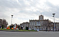
کاخ شهرداری تبریز | |
 South-western side of Saat Tower | |
 | |
| General information | |
| Type | Municipality Clock tower |
| Location | Tabriz, Iran |
| Coordinates | 38°04′25″N 46°17′44″E / 38.07361°N 46.29556°E |
| Completed | 1934 |
| Design and construction | |
| Architect(s) | Avedis Ohanjanian |
Sa'at Tower also known as Tabriz Municipality Palace (
History
Before
Current alterations
During the 1980s, in an attempt for installing an elevator, one of Saat's patios was damaged. The dome in top of the tower of Saat was reconstructed on 2008 with a new khaki colored fiber glass instead of the original silver colored dome. Since 2007, part of the building houses the Municipal Museum.
Architecture
This building has an area of about 9,600 square meters and 6,500 square meters of infrastructure, which is built on three floors. Tabriz Municipality Palace has a four-page clock tower with a height of 30.5 meters with the rhythmic resonance of its bells, every hour, it brings the passage of time to the ears of the people of Tabriz.The exterior of the building is carved out of stone and the plan of the building is similar to the design of a flying eagle, which corresponds to the example of buildings in Germany before World War II.[1]
Museum of Municipality
In recent years parts of the building is reorganized as municipality museum of Tabriz.
-
 Northern side of Saat Tower and municipality building from Saat square.
 -
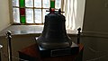 Former bell of Saat Tower which is damaged during Russian invasion of Tabriz during World War II. The bell later replaced by a new one.
 -
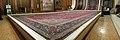 Main hall of Saat tower, currently is being used as show place for rug collection of Tabriz municipality.
 -
 Interior of Saat tower, under the southern Ivan.
 -
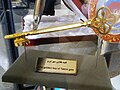 Golden key of Tabriz.
 -
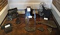 Some of the equipment presented in municipality museum.
 -
 Basement passage of municipality building.
 -
 Saat under construction, 1930s.
 -
 Western side of Municipality Building and Saat Tower, a view from municipality garden.


Ceremonies

Since Saat Tower is located in the center of the city, it has been used for various ceremonies and gatherings in the city.
- Iranian new year, at the beginning of every new Iranian Year (20 March), a big Haft-Sinis made behind Saat.
- Earth hour, since 2014 Tabriz celebrate the earth hour by turning off the lights for Saat Tower.[2]
Etymology
Sa'at means "clock", which refers to the four face clock in top of the tower.
References
- ^ Sa’at tower
- ^ "پایگاه اطلاع رسانی و فرهنگی شهریار". shahryarnews.net.
External links
![]() Media related to Saat Tower at Wikimedia Commons
Media related to Saat Tower at Wikimedia Commons