
Salamanca, Chile
Salamanca | |
|---|---|
 | |
.svg) Flag .svg) Coat of arms  Map of Salamanca in the Coquimbo Region UTC−3 (CLST) | |
| Area code | 56 + 53 |
| Website | Municipality of Salamanca |
Salamanca is a
Salamanca sits on the north bank of the Choapa River and within the Choapa valley. It was officially founded in 1844 by Joaquín de Ceballo, governor of Illapel.
It is served by Las Brujas Airport.
History


The city of Salamanca was founded on November 29, 1844, by the Acting Governor of Illapel
Of the many farms that were part of the Choapa Making, some were parceled under the Homestead Act of 1928. however, in 1959 when the Agrarian Reform Corporation does not acquire the National Health Service (legal successor of the Public Welfare), the estates that formed the Hacienda Choapa, they still amounted to 253,000 has, Of which. Just over 8,000 acres were irrigated.
In the late sixties as a result of the CORA program, a program of concentration of rural population Choapa Valley holds in villages that are located on both banks of the river of the same name, setting urban areas in 1982.
Early inhabitants
Its area has a long human occupation since the
Early occupation

Between 8000 and 2500 BC, walking these bands of hunter-gatherer land, which are transferred from the coast in search of food. Gradually accessing these groups will develop an incipient agriculture (especially corn) associated with hunting guanacos.
Between 300 BC and 200, burst into the valley agroalfareras populations originating in northwestern Argentina. Precisely these are from the first archaeological evidence of our past, as evidenced by the findings of St. Augustine, Grove, Chillepín, Panguesillo and Salamanca.
Molle culture
These people, of uncertain origin, lived in valleys and gorges, relying on agriculture and livestock. They had simple knowledge of gold, silver, and copper metallurgy. They make simple pottery, knew the use of snuff or the like in the region and introduce a lip ornament made of stone: the tembetá. Limited data on this culture for concluding that development in the area was marginal.
Diaguita culture
Theoretically it is believed that
Inca rule
The ruler
The Inca invasion left across the region Choapa its civilizing footprint, managing to introduce a more rational exploitation on crops, taught the construction of roads and irrigation canals, as likewise the production of textiles, pottery and various household utensils. After the Inca invasion of Chile, of the Cordilleran area Petorca spent the Inca Trail in central Chile. The same was followed by Diego de Almagro (1536) and Pedro de Valdivia (1540) to enter the Aconcagua Valley and the Valley of the Mapocho River. Is interesting to note the existence of vestiges of "this Inca road" route built to transport military, trade and communications to maintain Incanato. This road was part of a network of twenty thousand kilometers paths between mountains and valleys. Since much remains are known in the valleys and Alicahue Petorca. In 1984 a section up to Cuncumén and Conchuca the dairy farm (dairy farms were places of rest and replenishment) was discovered. There are precedents for the existence of a coastal Inca Trail (still unknown), it must have passed through La Serena, Illapel and Ligua.
Demographics
According to the 2002 census of the National Statistics Institute, Salamanca spans an area of 3,445.3 km2 (1,330 sq mi) and has 24,494 inhabitants (13,043 men and 11,451 women). Of these, 12,689 (51.8%) lived in urban areas and 11,805 (48.2%) in rural areas. The population grew by 5.9% (1,368 persons) between the 1992 and 2002 censuses.[2]
Administration

As a commune, Salamanca is a third-level
- Pedro Chávez González
- Roberto Rondanelli Hidalgo
- Rubén Sacre Barlaro
- Omar Alamos Calderón
- Carlos Rojas Tapia
- Enrique Tapia
Within the
Panorama

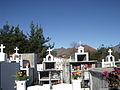
Municipal Cemetery Salamanca
-
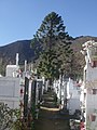 Municipal Cemetery Salamanca
 -
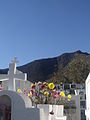
 The statue ofMary
 -

-
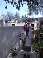
 Municipal Cemetery Salamanca (Right)
 -

-
-

.JPG)

.JPG)
_12.JPG)


Gallery
-

-
 The village of Chuchiñi
 -
 Neighborhoods in Salamanca
 -
 Plaza de Aguirre
.JPG)


References
- ^ a b "Municipality of Salamanca" (in Spanish). Archived from the original on 5 March 2002. Retrieved 13 November 2010.
- ^ a b c d "National Statistics Institute" (in Spanish). Retrieved 13 November 2010.
External links
- (in Spanish) Municipality of Salamanca
