
Salt Plains National Wildlife Refuge
| Salt Plains National Wildlife Refuge | |
|---|---|
IUCN category IV (habitat/species management area) | |
 The Salt Plains near the Crystal digging area | |
 Salt Plains  Salt Plains | |
| Location | Alfalfa County, Oklahoma |
| Nearest city | Jet |
| Coordinates | 36°45′01″N 98°13′27″W / 36.750314°N 98.224259°W |
| Area | 32,080 acres (129.8 km2) |
| Established | 1930 |
| Governing body | United States Fish and Wildlife Service |
| Website | Salt Plains National Wildlife Refuge |
| Designated | June 1983 |
The Salt Plains National Wildlife Refuge is part of the United States system of
The refuge was established March 26, 1930, by executive order of

Refuge description
The Salt Plains were a favorite hunting ground for American Indians. Bison and other game came to the area to eat the salt and the heavily wooded and well-watered area along the Salt Fork River was like an oasis in the surrounding grassland of the Great Plains. Salt Plains refuge is divided into almost equal areas of nonvegetated salt flat, open water, and vegetated land. Marshes, woods, grasslands, and croplands dot the refuge. Management tools used to enhance the habitat for wildlife include farming, grazing, prescribed burns, construction of ponds, and wetland draining and flooding.[2]
The refuge was created to be a resting and breeding ground for
Ralstin Island
Ralstin Island (closed to the public) is an important
History of the Great Salt Plains
Osage control of Great Salt Plains
According to Historian Louis F. Burns, the Osage Indians used the salt found in the Great Salt Plains to bleach deer-skins and the Great Salt Plains gave the Osages a surplus of salt to trade with other tribes. According to Burns, the Osage were firmly in control of the Great Salt Plains by 1760 and because of a favorable combination of geographical factors, the Osages became the dominant force in mid—America. "In a one hundred twenty-five year period, 1678-1803, the Osages performed a feat no other American Indians duplicated," writes Burns. "They stopped the west-ward expansion of the Euro-American peoples and simultaneously tripled the size of their own domain."[6]
Sibley Expedition
Native American usage
The Great Salt Plains have been the scene of many Indian Councils, both of war and peace. Because animals flocked to the area for the salt, the Great Salt Plains made for excellent hunting and it became obvious that any tribe that controlled the Salt Plains would have to contend with intrusions by other tribes. Therefore the Treaty of New Echota signed in 1835, provided the Cherokee Nation with ownership of the Cherokee Outlet but declared that the saline areas were to be accessible to use by other tribes. In drafting the treaty the United States Government withheld the Salt Plains area with the provision that, "The right is reserved to the United States to allow other tribes of red men to get salt on the Great Salt Plains in common with the Cherokee Tribe."[7][8][9]
Chemical weapons discovery
In 2007, a Boy Scout digging for crystals uncovered a collection of 7.5-inch vials containing chemical agents such as mustard gas, lewisite, chloropicrin, and phosgene.[10][11] The vials were part of World War II-era military chemical agent identification sets.[10] The burial of vials was standard procedure for removing them from service at that time. No record of a disposal site was reported at the salt plains. Crystal digging was suspended from April 2007 until April 2009, while the risk of allowing digging again was evaluated; 171 vials and at least a dozen incendiary devices were removed from the location.[10][12] The salt plains were also used as a
Recreation

Driving tour: The Harold F. Miller Auto Tour begins near the nature center. It is 2.5 miles (4 km) long and ends at Highway 11. The dirt road passes by ponds and fields where crops for wildlife are cultivated. White-tailed deer and other wildlife are common. A trail of 0.25 miles (400 m) leads to Casey Marsh Tower, where waterfowl are abundant and bald eagles can be seen in fall and winter.[15]
Hiking: The Sandpiper Trail begins near the nature center and refuge office and leads 0.35 miles (600 m) to the edge of the salt flats and a birding observation platform. The Eagle Roost Nature Trail is a 1.25-mile (2.0 km) loop also beginning near the nature center. The trail goes through wooded and open areas, beneath towering cottonwood trees, past marshes and ponds, and to a shore and waterfowl watching area on Sand Creek Bay.[15]
Selenite crystals: A designated area of the 11,000 acres (45 km2) of salt flats at the refuge has
-
 A hole dug in the Digging Area
 -
 Many selenite crystals found in a single day
 -
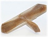 Blade / penetration twins type of selenite crystal


Hunting: About 1,250 acres (5 km2) of the refuge north of Highway 11 are open for hunting. State laws apply, except deer may be hunted by permit only. Hunting is permitted for pheasant, northern bobwhite quail, mourning dove, ducks, geese, and sandhill cranes.[18]
Fishing: According to the U.S. Army Corps of Engineers, the extreme drought of 2011 and 2012 has almost ended fishing as a recreational activity at the refuge. These conditions caused very large fish kills in the reservoir and restocking has been suspended. Fishing downstream of the dam is still permitted, but is greatly affected by local precipitation and the flow of the Great Salt River.[19]
Information that follows indicate the practices in force prior to the 2011 drought, and may no longer apply: Fishing is permitted from April 1 to October 15 on most of the refuge. Closed areas are marked by buoys or signs. Fishing in Bonham Pond is permitted only for children under 14 and mobility-handicapped persons and is catch-and-release. Salt Plains Lake is noted for large channel and other catfish. Other game fish include striped bass, largemouth bass, crappie, white bass, panfish, and walleye. State laws apply for bag limits and seasons, and the use of boats in the river and creeks is prohibited.[20]
See also
- Great Salt Plains State Park
- Central Great Plains (ecoregion)
- The Great Plains Ecoregion
References
- ^ "National Natural Landmarks - National Natural Landmarks (U.S. National Park Service)". www.nps.gov. Retrieved March 26, 2019.
Year designated: 1983
- ^ Salt Plains - Brochures
- ^ Salt Plains - Welcome
- ^ "List of Sites". www.whsrn.org. Western Hemisphere Shorebird Reserve Network. Archived from the original on July 29, 2010. Retrieved June 7, 2023.
- ^ U.S. Fish and Wildlife Service. "Salt Plains National Wildlife Refuge." Retrieved April 20, 2013.[1]
- ISBN 9780817350185
- ^ a b Corps of Engineers. "History of Great Salt Plains Lake" retrieved May 25, 2021
- ^ a b Oklahoma Historical Society. "GREAT SALT PLAINS" retrieved May 25, 2021.
- ^ a b Oklahoma Historical Society. "Sibley Expeditions" retrieved May 25, 2021.
- ^ a b c "Crystal dig to open Saturday", Enid News & Eagle, April 18, 2009
- ^ Fitzgerald, Scott, "Salt Plains beds yield 130-plus chemical vials", Enid News & Eagle, May 1, 2007
- ^ Fitzgerald, Scott, "Incendiary devices found near chemicals at Salt Plains dig area", Enid News & Eagle, May 4, 2007
- ^ Barron, Robert, "Officials speculate chemical at Salt Plains could be mustard gas", Enid News & Eagle, April 26, 2007
- ^ "Scout unearths chemical; Salt Plains crystal beds under guard, are off-limits to public", Enid News & Eagle, April 24, 2007
- ^ a b "Salt Plains NWR Nature Trails". Archived from the original on February 6, 2007.
- ^ "Salt Plains - Selenite Crystals". U.S. Fish & Wildlife Service. Retrieved May 9, 2016.
- ^ "Salt Plains - Crystal Digging". U.S. Fish & Wildlife Service. Retrieved May 9, 2016.
- ^ Hunting at Salt Plains
- ^ US Army Corps of Engineers:Great Salt Plains Recreation. "Great Salt Plains Lake." Accessed April 20, 2015.
- ^ Fishing at Salt Plains
![]() This article incorporates public domain material from websites or documents of the United States Fish and Wildlife Service.
This article incorporates public domain material from websites or documents of the United States Fish and Wildlife Service.
External links
Informational videos
Official Great Salt Plains videos have been created and are hosted on YouTube. They are part of a short series, which includes: