
Schongau, Bavaria
Schongau | |
|---|---|
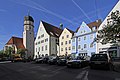
 General view of Schongau | |
 Coat of arms | |
Location of Schongau within Weilheim-Schongau district  | |
Weilheim-Schongau | |
| Government | |
| • Mayor (2020–26) | Falk Sluyterman van Langeweyde[1] (SPD) |
| Area | |
| • Total | 21.35 km2 (8.24 sq mi) |
| Elevation | 726 m (2,382 ft) |
| Population (2022-12-31)[2] | |
| • Total | 12,648 |
| • Density | 590/km2 (1,500/sq mi) |
| Time zone | UTC+01:00 (CET) |
| • Summer (DST) | UTC+02:00 (CEST) |
| Postal codes | 86956 |
| Dialling codes | 08861 |
| Vehicle registration | WM, SOG |
| Website | www.schongau.de |
Schongau is a town in Bavaria, near the Alps. It is located along the Lech, between Landsberg am Lech and Füssen. It has about 12,000 inhabitants. Schongau has a well-preserved old wall around the center.
Local history
The origin of Schongau is the current Altenstadt (lit.: old town). A large number of the inhabitants moved only a few kilometres into a new settlement founded on the Lech and took the name Schongau with them in the 13th century. The hillside was far better situated to defend it. The town of Schongau is located very close to the former Roman road to Augsburg, Via Claudia Augusta (47 AD), and gets its name from the Romans. In the Middle Ages, it was an important hub and commercial centre on the Verona-Augsburg-Nuremberg route and on the salt road from Berchtesgadener Land into the Allgäu.
Lechrain, populated by the Alemanni, was under the rule of the Swabian
Emperor Ludwig the Bavarian had given Schongau the right to mint in 1331.[4] Duke Christoph der Starke liked to stay in the city.[5] Christophstrasse in the historic centre of the town is named after him. On 22 May 1493, a devastating fire destroyed large parts of the Oberstadt (upper town) and the ducal palace; it was not until 1514 that reconstruction was completed.[4][5] Schongau was involved several times in martial conflicts and was often a transit camp for friendly and hostile troops.
Through trade and the diligence of its citizens, Schongau experienced a period of prosperity until the time of the European discovery of the Americas, which resulted in the relocation of the great trade routes. As a result, the city became so poor that significant buildings such as the castle and balehouse fell into partial decay or were demolished. After the Second World War, the city and the surrounding area gained a considerable number of residents due to refugees and developed into a district with relatively low unemployment due to the prosperous middle class.
The city had the first railroad connection with the Landsberg am Lech railway line to Schongau on 16 November 1886. The railway connection in the direction of Weilheim was opened on January 12, 1917, with the section from Peissenberg to Schongau on the railway line Weilheim-Schongau. The Kaufbeuren-Schongau railway line existed from 1923 to 1977; it was built because of mining in Peiting.
Schongau used to be a county of the same name. Due to the Bavarian district reform in 1972, it merged with the Weilheim district into today's Weilheim-Schongau county. In the town there are still some institutions from the county authority, and the name Altlandkreis Schongau (lit.: old county of Schongau) is still occasionally used.
Transport
The town has a railway station, Schongau, on the Schongau–Peißenberg line.
Popular culture
Schongau and the nearby area is the setting of the Oliver Pötzsch novel The Hangman's Daughter.
Twin towns
 Colmar (France) since 1962
 Lucca (Italy) since 1962[6]
 Sint-Niklaas (Belgium) since 1962
- Abingdon, Oxfordshiresince 1970
 Gogolin (Poland) since 1996
Mayor
Since May 1, 2014, the mayor of Schongau has been Falk Sluyterman van Langeweyde (SPD). He was elected in March 2014 with 50.3% of the votes.[7] His predecessor was Karl-Heinz Gerbl (SPD); he was in office from 2008 to 2014.
Sons and daughters of the town
- Reinhold Bocklet (born 1943), CSU politician
- Michael Kreitl (born 1975), ice hockey player
- Franz Rupp (1901-1992), pianist
- Stefan Schauer (born 1983), ice hockey player
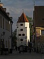
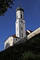
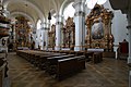
Photo gallery
- Schongau
-
-

-
-

-
-
-

-

-

-


References
- Bayerisches Landesamt für Statistik, 15 July 2021.
- ^ Genesis Online-Datenbank des Bayerischen Landesamtes für Statistik Tabelle 12411-003r Fortschreibung des Bevölkerungsstandes: Gemeinden, Stichtag (Einwohnerzahlen auf Grundlage des Zensus 2011) (Hilfe dazu).
- ^ Jan Puhl: Tod durch das Schwert. Spiegel Geschichte, 27. August 2010, retrieved 19 March 2014.
- ^ ISBN 3-87490-585-3, p 372.
- ^ a b Sigfrid Hofmann: Geschichte der Stadt Schongau. In: Schongau Herzstück des Pfaffenwinkels. p 46.
- ^ "Italy, image by deizenov". Mapillary. Retrieved 9 July 2019.
- ^ "Bürgermeisterwahl 2014 – Endergebnis" (in German). Stadt Schongau. Retrieved 1 May 2014.
| International | |
|---|---|
| National | |
| Geographic | |
This Weilheim-Schongau location article is a stub. You can help Wikipedia by expanding it. |