
Seddon, New Zealand
Seddon | |
|---|---|
Town | |
UTC+13 (New Zealand Daylight Time) | |
| Postcode | 7210 |
Seddon is a small town in
Salt and lime
The town was named for a former Prime Minister of New Zealand, Richard Seddon.
Geography
Earthquakes
Seddon has been close to the epicentres of several significant earthquakes.
On the morning of 16 October 1848, Marlborough was struck by a damaging earthquake later estimated to be between magnitude 7.4 and 7.7.[7] The epicentre of this earthquake was 45 km southeast of Seddon.[8]
On 23 April 1966, a magnitude 5.8 earthquake with an epicentre in Cook Strait, 40 km east of Seddon[9] was most strongly felt in the town, damaging the chimney on almost every house in town.[10]
In July and August 2013 Seddon was closest settlement to the epicentres of a
Demographics
Seddon is defined by Statistics New Zealand as a rural settlement. It covers 1.66 km2 (0.64 sq mi)[1] and had an estimated population of 600 as of June 2023,[2] with a population density of 361 people per km2. It is part of the wider Awatere statistical area.[15]
| Year | Pop. | ±% p.a. |
|---|---|---|
| 2006 | 495 | — |
| 2013 | 489 | −0.17% |
| 2018 | 552 | +2.45% |
| Source: [16] | ||
Seddon had a population of 552 at the
Ethnicities were 78.3% European/Pākehā, 16.8% Māori, 13.0% Pasifika, 2.7% Asian, and 2.7% other ethnicities. People may identify with more than one ethnicity.
Although some people chose not to answer the census's question about religious affiliation, 56.0% had no religion, 27.7% were Christian, 0.5% had Māori religious beliefs, 0.5% were Muslim and 2.2% had other religions.
Of those at least 15 years old, 30 (6.6%) people had a bachelor's or higher degree, and 126 (27.6%) people had no formal qualifications. 33 people (7.2%) earned over $70,000 compared to 17.2% nationally. The employment status of those at least 15 was that 261 (57.2%) people were employed full-time, 66 (14.5%) were part-time, and 12 (2.6%) were unemployed.[16]
Transport
The Marlborough section of the Main North Line railway reached Seddon from Blenheim in October 1902.[17] This also saw the construction of a combined road-rail bridge over the Awatere River north of the town, with the single-lane road below the rail. The bridge remained in service for road traffic until October 2007, when a new two-lane road bridge opened.[18] Seddon was the southern terminus of the railway until the line was extended to Ward in April 1911; the full line through to Christchurch didn't open until December 1945.[17] Today, Seddon is served by the Coastal Pacific train, which runs once daily each way during the summer months.
A train derailment at Blind River, south of Seddon, on 25 February 1948, killed six people and injured 40 others.[19]
-
 The double decker bridge across the Awatere River
 -
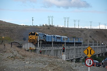 Trains use the upper level of the bridge. Road transport used the lower level until a new bridge was opened in November 2007.


Education
Seddon School is the sole school in the town. It is a coeducational full primary (year 1–8) school with a roll of 132 as of February 2024.[20] The nearest state secondary schools are Marlborough Boys' College and Marlborough Girls' College in Blenheim.
References
- ^ a b "ArcGIS Web Application". statsnz.maps.arcgis.com. Retrieved 24 July 2023.
- ^ a b "Subnational population estimates (RC, SA2), by age and sex, at 30 June 1996-2023 (2023 boundaries)". Statistics New Zealand. Retrieved 25 October 2023. (regional councils); "Subnational population estimates (TA, SA2), by age and sex, at 30 June 1996-2023 (2023 boundaries)". Statistics New Zealand. Retrieved 25 October 2023. (territorial authorities); "Subnational population estimates (urban rural), by age and sex, at 30 June 1996-2023 (2023 boundaries)". Statistics New Zealand. Retrieved 25 October 2023. (urban areas)
- ISBN 0-7900-0952-8.
- ISBN 1-877333-20-4.
- Encyclopedia of New Zealand (1966).
- ^ "Awatere River". Marlborough Online.
- ^ "M 7.4 - 7.7, Marlborough, 16 October 1848". Geonet. GNS Science. Retrieved 18 August 2013.
- ^ "New Zealand Earthquake Report Magnitude 7.4, Monday, October 16, 1848 at 1:49:04 am (NZST)". Geonet. GNS Science. 24 October 2008. Retrieved 18 August 2013.
- ^ "New Zealand Earthquake Report Magnitude 5.8, Saturday, April 23, 1966 at 6:49:40 pm (NZDT)". Geonet. GNS Science. 30 August 1996. Retrieved 18 August 2013.
- ^ "M 5.8, Seddon, 23 April 1966". Geonet. GNS Science. Retrieved 18 August 2013.
- ^ Fenaughty, Kevin (17 August 2013). "Damaging quake hits the north-east of the South Island". Geonet. GNS Science. Retrieved 17 August 2013.
- ^ "Big quake shakes central New Zealand". Stuff.co.nz. 21 July 2013. Retrieved 17 August 2013.
- ^ "Earthquakes rock central New Zealand". Stuff.co.nz. 17 August 2013. Retrieved 17 August 2013.
- ^ "Google Maps".
- ^ 2018 Census place summary: Awatere
- ^ a b "Statistical area 1 dataset for 2018 Census". Statistics New Zealand. March 2020. 7023538–7023540.
- ^ a b "Geographical Mileage Table 1957" (PDF). New Zealand Railways. Retrieved 29 December 2015.
- The Marlborough Express. 9 November 2007. Archivedfrom the original on 11 September 2012.
- ISBN 0-473-10475-X.
- ^ "New Zealand Schools Directory". New Zealand Ministry of Education. Retrieved 14 March 2024.
External links
 Media related to Seddon, New Zealand at Wikimedia Commons
| International | |
|---|---|
| National | |