
Siccar Point
Siccar Point | |
|---|---|
IUGS Geological Heritage Site |
Siccar Point is a rocky promontory in the county of Berwickshire on the east coast of Scotland. It is famous in the history of geology for Hutton's Unconformity found in 1788, which James Hutton regarded as conclusive proof of his uniformitarian theory of geological development.
History

Siccar Point was the site of a
Siccar Point is now in the parish of
To the south of the point twentieth-century quarrying for greywacke to be used as roadstone left a hollow named Old Cambus Quarry which is now occupied by a vegetable distribution warehouse complex.[1]
Hutton's Unconformity
Siccar Point is notable in the history of geology as a result of a boat trip in 1788 in which geologist James Hutton observed the angular unconformity of the point.[2] He wrote later that the evidence of the rocks provided conclusive proof of the
-
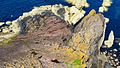 The rugged point, seen from above, shows gently sloping beds of red sandstone above vertical beds of greywacke, forming a classic example of Hutton's Unconformity.
 -
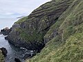
 The eroded sandstone outcrop above conglomerate and vertical ribs of greywacke, still much as when sketched in 1788 by Hutton's companion Sir James Hall.
 -
![Field sketch of Hutton's Unconformity at Siccar Point, Scotland by Sir James Hall (1788).[2]](//upload.wikimedia.org/wikipedia/commons/thumb/8/8a/Huttons_Unconformity_at_Sicar_Point_by_James_Hall_%281788%29.jpg/120px-Huttons_Unconformity_at_Sicar_Point_by_James_Hall_%281788%29.jpg) Field sketch of Hutton's Unconformity at Siccar Point, Scotland by Sir James Hall (1788).[2]
Field sketch of Hutton's Unconformity at Siccar Point, Scotland by Sir James Hall (1788).[2] -
 Headlands south of Siccar Point showing tilted strata and unconformities


![Field sketch of Hutton's Unconformity at Siccar Point, Scotland by Sir James Hall (1788).[2]](/File:Huttons_Unconformity_at_Sicar_Point_by_James_Hall_(1788).jpg)

See also
References
- ^ Cliff Ford (2 September 2003). "Siccar Point: Safety". Field Excursion Preview. University of Edinburgh School of GeoSciences. Archived from the original on 14 February 2012. Retrieved 20 October 2008.
- ^ a b Kerr, Andrew (2018). "Classic Rock Tours 1. Hutton's Unconformity at Siccar Point, Scotland: A Guide for Visiting the Shrine on the Abyss of Time". Geoscience Canada. 45 (1). The Geological Association of Canada: 27–42. . Retrieved 21 March 2022.
- ^ "The First 100 IUGS Geological Heritage Sites" (PDF). IUGS International Commission on Geoheritage. IUGS. Retrieved 2 November 2022.
External links
- John Playfair's historic remarks upon seeing Siccar Point, in vol. V, pt. III, 1805, Transactions of the Royal Society of Edinburgh.
- Research Casting International hung on scaffolding off the cliffs at Siccar Point, painting a large section of the rocks with thick liquid latex (photo) to fabricate an exhibit for the Gottesman Hall of Planet Earth, American Museum of Natural History.
- Map sources for Siccar Point
- VFE: Siccar Point, Scotland — virtual excursion in Historical Geology (A free online textbook for Historical Geology courses)
| Authority control databases: National |
|---|